
Easier access to scientific data

Brought to you by NOAA CoastWatch Great Lakes Node
|
ERDDAP
Easier access to scientific data |
|
Brought to you by NOAA CoastWatch Great Lakes Node |
| Dataset Title: | Lake Superior Eastern Region Surface Temperature Contour Map (2022-present)


|
| Institution: | CoastWatch Great Lakes Node (Dataset ID: LS_NRT_TC_s3) |
| Information: | Summary
| License
| Metadata
| Background | Subset
| Data Access Form
| Make a graph
| Subset
| Data Access Form
| Make a graph
|
![[ICO]](https://apps.glerl.noaa.gov/erddap/images/fileIcons/blank.gif) | Name | Last modified | Size | Description |
|---|---|---|---|---|
![[DIR]](https://apps.glerl.noaa.gov/erddap/images/fileIcons/back.gif) | Parent Directory | - | - | |
![[IMG]](https://apps.glerl.noaa.gov/erddap/images/fileIcons/image2.gif)  | s3_2023_10_22_0140.png | 22-Oct-2023 05:27 | 51124 | |
 | s3_2023_10_22_0240.png | 22-Oct-2023 05:31 | 53262 | |
 | s3_2023_10_22_0320.png | 22-Oct-2023 06:25 | 38244 | |
 | s3_2023_10_22_0710.png | 22-Oct-2023 17:27 | 41563 | |
 | s3_2023_10_22_0800.png | 22-Oct-2023 17:30 | 44177 | |
 | s3_2023_10_22_1450.png | 22-Oct-2023 19:25 | 48501 | |
 | s3_2023_10_22_1540.png | 22-Oct-2023 19:29 | 58494 | |
 | s3_2023_10_22_1630.png | 22-Oct-2023 20:25 | 68596 | |
 | s3_2023_10_22_1700.png | 22-Oct-2023 19:32 | 47129 | |
 | s3_2023_10_22_1750.png | 22-Oct-2023 22:25 | 70531 | |
 | s3_2023_10_22_1840.png | 22-Oct-2023 21:27 | 68416 | |
 | s3_2023_10_22_1930.png | 22-Oct-2023 23:25 | 74845 | |
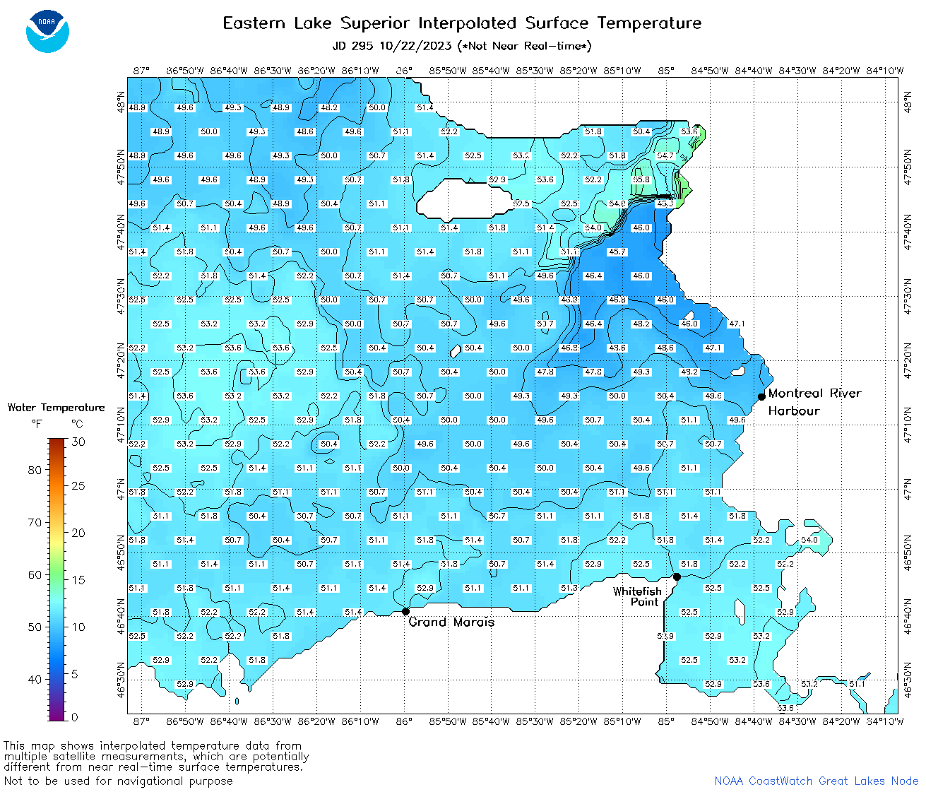 | s3_2023_295.png | 23-Oct-2023 09:10 | 77544 | |