
Easier access to scientific data

Brought to you by NOAA CoastWatch Great Lakes Node
|
ERDDAP
Easier access to scientific data |
|
Brought to you by NOAA CoastWatch Great Lakes Node |
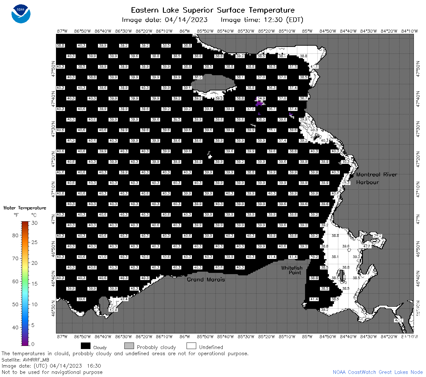
| Dataset Title: | Lake Superior Eastern Region Surface Temperature Contour Map (2022-present)


|
| Institution: | CoastWatch Great Lakes Node (Dataset ID: LS_NRT_TC_s3) |
| Information: | Summary
| License
| Metadata
| Background | Subset
| Data Access Form
| Make a graph
| Subset
| Data Access Form
| Make a graph
|
![[ICO]](https://apps.glerl.noaa.gov/erddap/images/fileIcons/blank.gif) | Name | Last modified | Size | Description |
|---|---|---|---|---|
![[DIR]](https://apps.glerl.noaa.gov/erddap/images/fileIcons/back.gif) | Parent Directory | - | - | |
![[IMG]](https://apps.glerl.noaa.gov/erddap/images/fileIcons/image2.gif)  | s3_2023_04_14_0150.png | 14-Apr-2023 05:27 | 46936 | |
 | s3_2023_04_14_0240.png | 14-Apr-2023 05:32 | 47487 | |
 | s3_2023_04_14_0330.png | 14-Apr-2023 06:25 | 45149 | |
 | s3_2023_04_14_0650.png | 14-Apr-2023 09:25 | 99063 | |
 | s3_2023_04_14_0740.png | 14-Apr-2023 11:25 | 88452 | |
 | s3_2023_04_14_0830.png | 14-Apr-2023 11:30 | 92427 | |
 | s3_2023_04_14_1450.png | 14-Apr-2023 17:25 | 46125 | |
 | s3_2023_04_14_1540.png | 14-Apr-2023 19:25 | 44898 | |
 | s3_2023_04_14_1630.png | 14-Apr-2023 19:28 | 44710 | |
 | s3_2023_04_14_1730.png | 14-Apr-2023 20:25 | 87733 | |
 | s3_2023_04_14_1820.png | 14-Apr-2023 21:27 | 77976 | |
 | s3_2023_04_14_1910.png | 14-Apr-2023 22:25 | 67258 | |
 | s3_2023_104.png | 15-Apr-2023 09:10 | 64361 | |