
Easier access to scientific data

Brought to you by NOAA CoastWatch Great Lakes Node
|
ERDDAP
Easier access to scientific data |
|
Brought to you by NOAA CoastWatch Great Lakes Node |
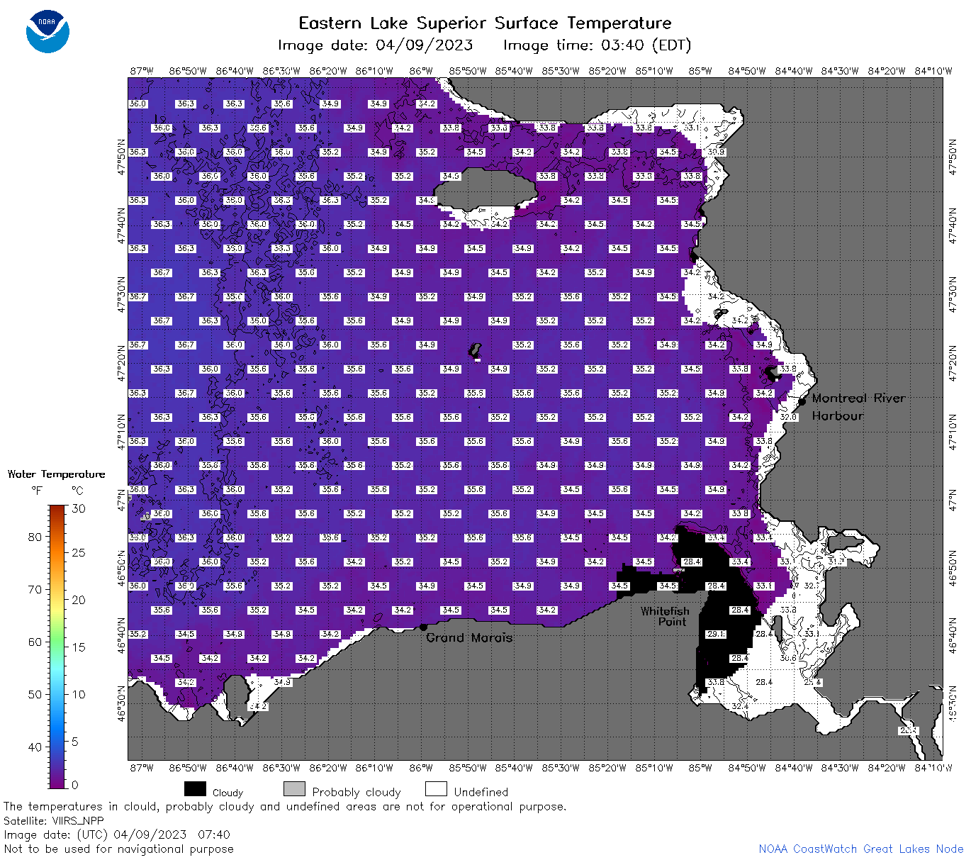
| Dataset Title: | Lake Superior Eastern Region Surface Temperature Contour Map (2022-present)


|
| Institution: | CoastWatch Great Lakes Node (Dataset ID: LS_NRT_TC_s3) |
| Information: | Summary
| License
| Metadata
| Background | Subset
| Data Access Form
| Make a graph
| Subset
| Data Access Form
| Make a graph
|
![[ICO]](https://apps.glerl.noaa.gov/erddap/images/fileIcons/blank.gif) | Name | Last modified | Size | Description |
|---|---|---|---|---|
![[DIR]](https://apps.glerl.noaa.gov/erddap/images/fileIcons/back.gif) | Parent Directory | - | - | |
![[IMG]](https://apps.glerl.noaa.gov/erddap/images/fileIcons/image2.gif)  | s3_2023_04_09_0150.png | 09-Apr-2023 05:28 | 109591 | |
 | s3_2023_04_09_0240.png | 09-Apr-2023 05:30 | 149552 | |
 | s3_2023_04_09_0330.png | 09-Apr-2023 06:25 | 100347 | |
 | s3_2023_04_09_0650.png | 09-Apr-2023 10:29 | 122102 | |
 | s3_2023_04_09_0740.png | 09-Apr-2023 11:25 | 110098 | |
 | s3_2023_04_09_0830.png | 09-Apr-2023 11:28 | 106946 | |
 | s3_2023_04_09_0920.png | 09-Apr-2023 13:25 | 37267 | |
 | s3_2023_04_09_1450.png | 09-Apr-2023 17:25 | 43260 | |
 | s3_2023_04_09_1550.png | 09-Apr-2023 19:27 | 43185 | |
 | s3_2023_04_09_1630.png | 09-Apr-2023 19:30 | 43555 | |
 | s3_2023_04_09_1720.png | 09-Apr-2023 20:26 | 85587 | |
 | s3_2023_04_09_1810.png | 09-Apr-2023 21:29 | 79580 | |
 | s3_2023_04_09_1900.png | 09-Apr-2023 22:25 | 88433 | |
 | s3_2023_099.png | 10-Apr-2023 09:10 | 62731 | |