
Easier access to scientific data

Brought to you by NOAA CoastWatch Great Lakes Node
|
ERDDAP
Easier access to scientific data |
|
Brought to you by NOAA CoastWatch Great Lakes Node |
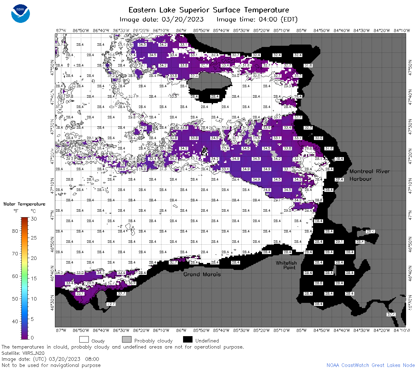
| Dataset Title: | Lake Superior Eastern Region Surface Temperature Contour Map (2022-present)


|
| Institution: | CoastWatch Great Lakes Node (Dataset ID: LS_NRT_TC_s3) |
| Information: | Summary
| License
| Metadata
| Background | Subset
| Data Access Form
| Make a graph
| Subset
| Data Access Form
| Make a graph
|
![[ICO]](https://apps.glerl.noaa.gov/erddap/images/fileIcons/blank.gif) | Name | Last modified | Size | Description |
|---|---|---|---|---|
![[DIR]](https://apps.glerl.noaa.gov/erddap/images/fileIcons/back.gif) | Parent Directory | - | - | |
![[IMG]](https://apps.glerl.noaa.gov/erddap/images/fileIcons/image2.gif)  | s3_2023_03_20_0110.png | 22-Mar-2023 18:39 | 65180 | |
 | s3_2023_03_20_0210.png | 22-Mar-2023 18:43 | 79844 | |
 | s3_2023_03_20_0250.png | 22-Mar-2023 18:45 | 94688 | |
 | s3_2023_03_20_0350.png | 22-Mar-2023 18:49 | 58798 | |
 | s3_2023_03_20_0620.png | 22-Mar-2023 18:51 | 40710 | |
 | s3_2023_03_20_0710.png | 22-Mar-2023 18:53 | 80508 | |
 | s3_2023_03_20_0800.png | 22-Mar-2023 18:56 | 83171 | |
 | s3_2023_03_20_0850.png | 22-Mar-2023 18:58 | 75413 | |
 | s3_2023_03_20_1510.png | 22-Mar-2023 19:04 | 72818 | |
 | s3_2023_03_20_1600.png | 22-Mar-2023 19:06 | 86587 | |
 | s3_2023_03_20_1650.png | 22-Mar-2023 19:08 | 78485 | |
 | s3_2023_03_20_1700.png | 22-Mar-2023 19:10 | 61825 | |
 | s3_2023_03_20_1750.png | 22-Mar-2023 19:16 | 83439 | |
 | s3_2023_03_20_1840.png | 22-Mar-2023 19:19 | 86807 | |
 | s3_2023_03_20_1930.png | 22-Mar-2023 19:21 | 76803 | |
 | s3_2023_079.png | 21-Mar-2023 09:10 | 69878 | |