
Easier access to scientific data

Brought to you by NOAA CoastWatch Great Lakes Node
|
ERDDAP
Easier access to scientific data |
|
Brought to you by NOAA CoastWatch Great Lakes Node |
| Dataset Title: | Lake Superior Eastern Region Surface Temperature Contour Map (2022-present)


|
| Institution: | CoastWatch Great Lakes Node (Dataset ID: LS_NRT_TC_s3) |
| Information: | Summary
| License
| Metadata
| Background | Subset
| Data Access Form
| Make a graph
| Subset
| Data Access Form
| Make a graph
|
![[ICO]](https://apps.glerl.noaa.gov/erddap/images/fileIcons/blank.gif) | Name | Last modified | Size | Description |
|---|---|---|---|---|
![[DIR]](https://apps.glerl.noaa.gov/erddap/images/fileIcons/back.gif) | Parent Directory | - | - | |
![[IMG]](https://apps.glerl.noaa.gov/erddap/images/fileIcons/image2.gif)  | s3_2023_02_13_0140.png | 13-Feb-2023 06:24 | 36764 | |
 | s3_2023_02_13_0230.png | 13-Feb-2023 06:25 | 38648 | |
 | s3_2023_02_13_0320.png | 13-Feb-2023 06:26 | 35958 | |
 | s3_2023_02_13_0630.png | 13-Feb-2023 10:24 | 46727 | |
 | s3_2023_02_13_0720.png | 13-Feb-2023 10:25 | 48917 | |
 | s3_2023_02_13_0810.png | 13-Feb-2023 12:24 | 44244 | |
 | s3_2023_02_13_0900.png | 13-Feb-2023 12:25 | 45436 | |
 | s3_2023_02_13_1440.png | 13-Feb-2023 18:24 | 39041 | |
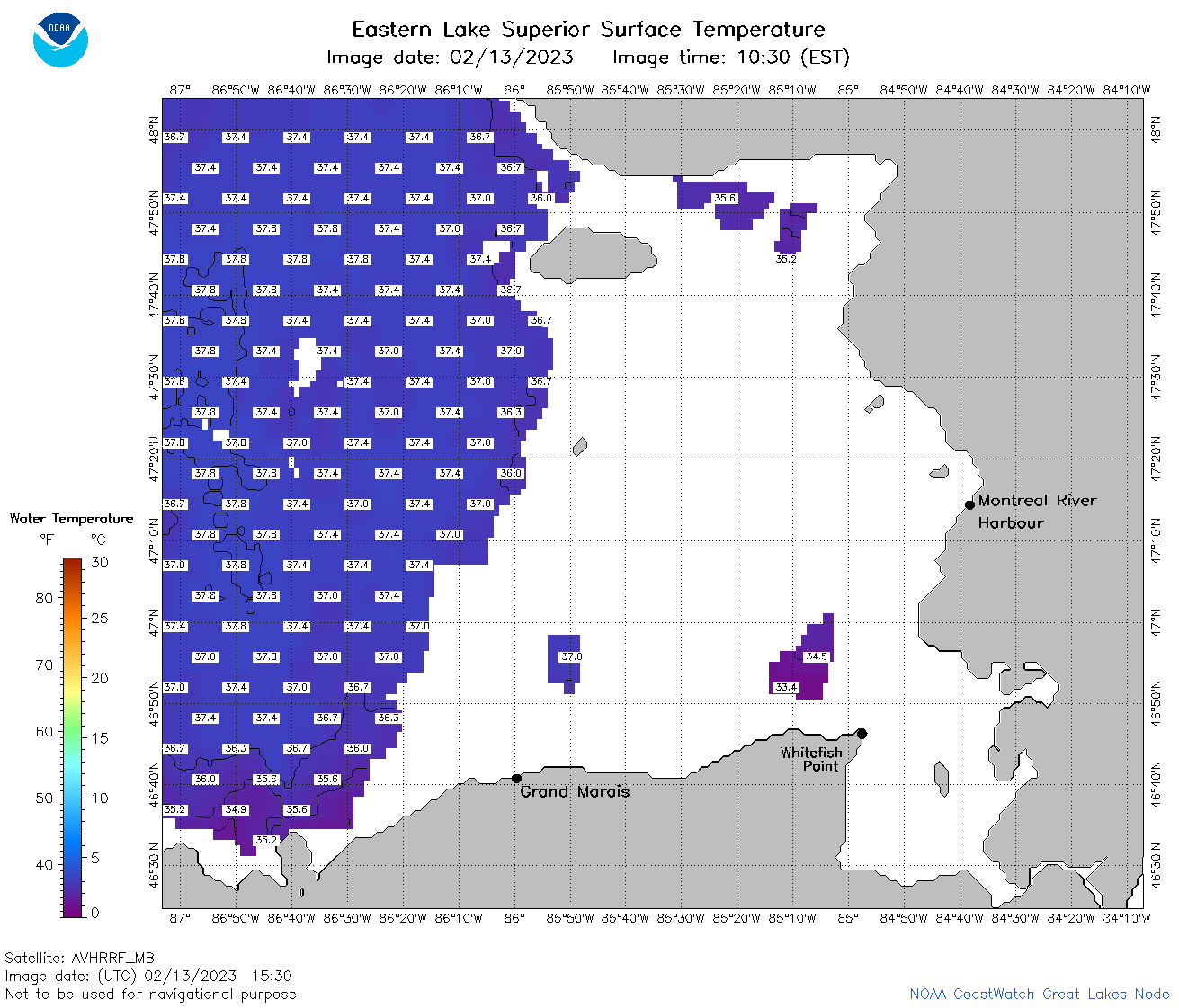 | s3_2023_02_13_1530.png | 13-Feb-2023 18:25 | 46555 | |
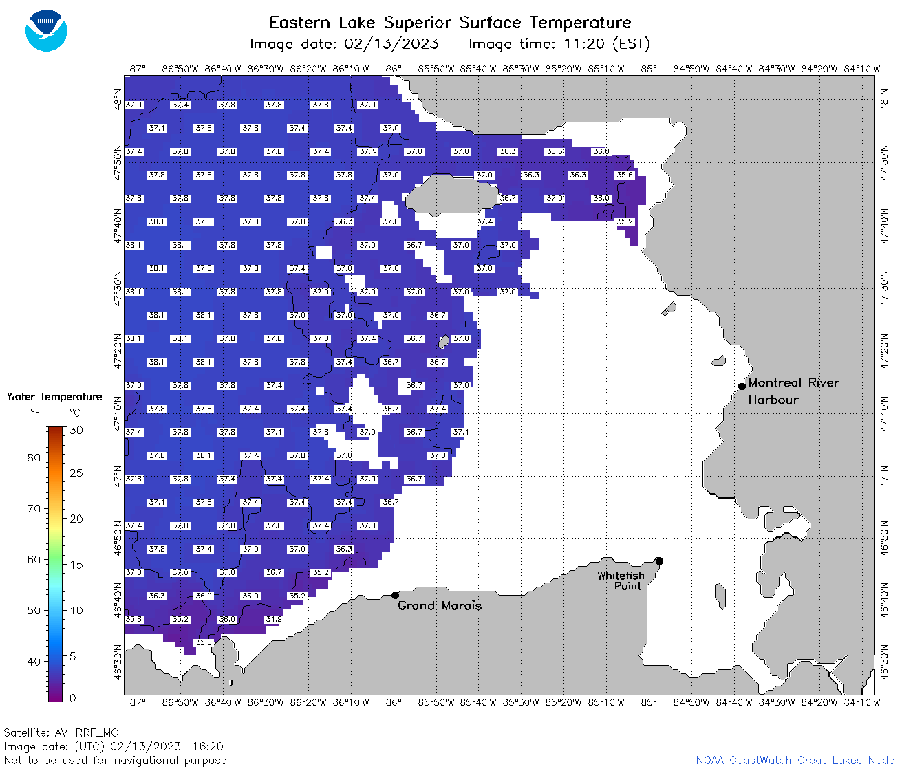 | s3_2023_02_13_1620.png | 13-Feb-2023 20:24 | 49184 | |
 | s3_2023_02_13_1700.png | 13-Feb-2023 20:26 | 48611 | |
 | s3_2023_02_13_1710.png | 13-Feb-2023 20:26 | 37136 | |
 | s3_2023_02_13_1750.png | 13-Feb-2023 20:27 | 53114 | |
 | s3_2023_02_13_1840.png | 13-Feb-2023 22:24 | 53624 | |
 | s3_2023_02_13_1930.png | 13-Feb-2023 22:25 | 50798 | |
 | s3_2023_02_13_1940.png | 13-Feb-2023 22:26 | 34078 | |
 | s3_2023_044.png | 14-Feb-2023 10:10 | 67353 | |