
Easier access to scientific data

Brought to you by NOAA CoastWatch Great Lakes Node
|
ERDDAP
Easier access to scientific data |
|
Brought to you by NOAA CoastWatch Great Lakes Node |
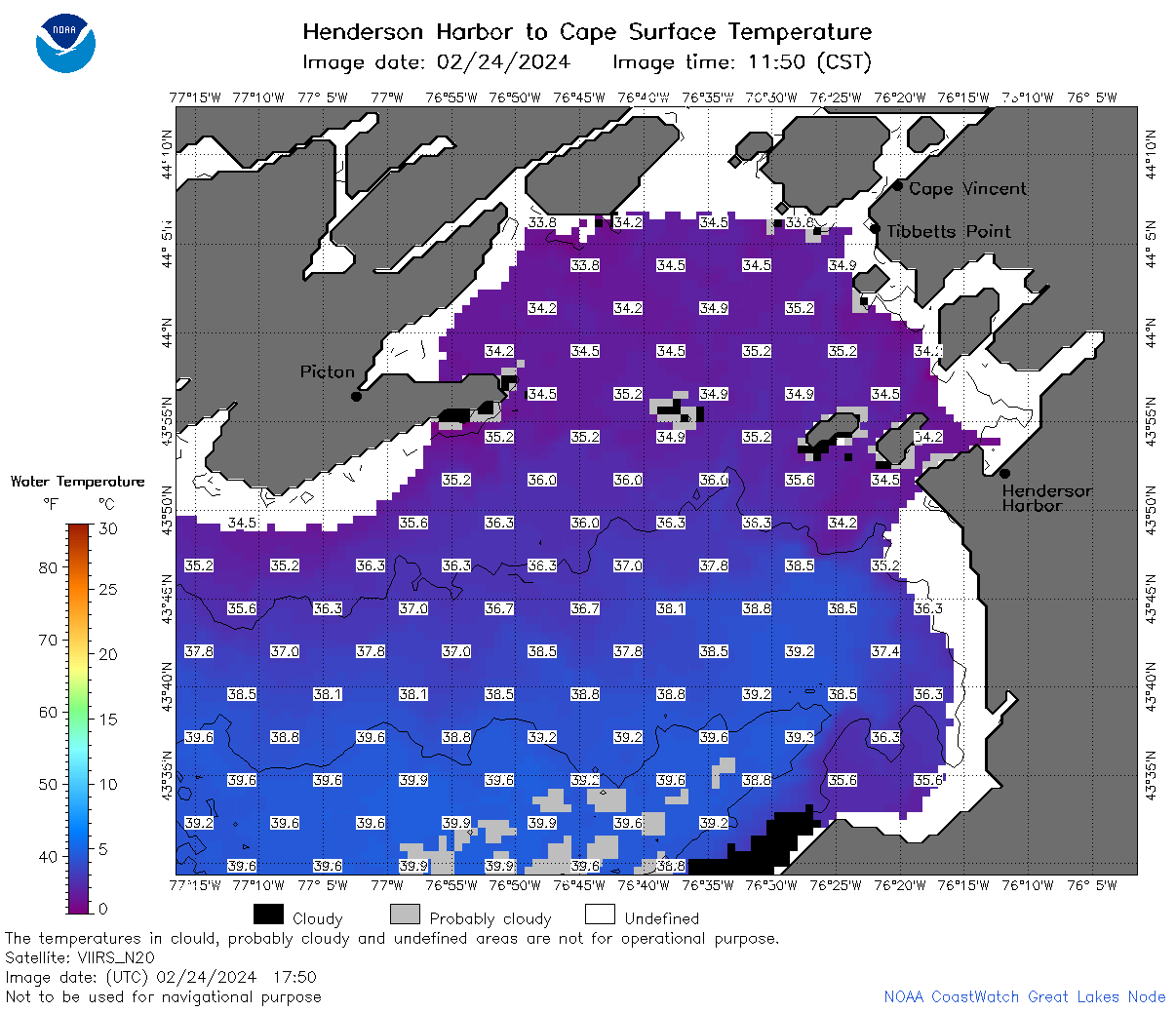
| Dataset Title: | Lake Ontario Henderson Harbor to Cape Vincent Surface Temperature Contour Map (2022-present) 

|
| Institution: | CoastWatch Great Lakes Node (Dataset ID: LO_NRT_TC_o23) |
| Information: | Summary
| License
| Metadata
| Background | Subset
| Data Access Form
| Make a graph
| Subset
| Data Access Form
| Make a graph
|
![[ICO]](https://apps.glerl.noaa.gov/erddap/images/fileIcons/blank.gif) | Name | Last modified | Size | Description |
|---|---|---|---|---|
![[DIR]](https://apps.glerl.noaa.gov/erddap/images/fileIcons/back.gif) | Parent Directory | - | - | |
![[IMG]](https://apps.glerl.noaa.gov/erddap/images/fileIcons/image2.gif)  | o23_2024_02_24_0110.png | 24-Feb-2024 09:31 | 31287 | |
 | o23_2024_02_24_0150.png | 24-Feb-2024 09:33 | 27078 | |
 | o23_2024_02_24_0200.png | 24-Feb-2024 09:35 | 32394 | |
 | o23_2024_02_24_0250.png | 24-Feb-2024 09:38 | 30793 | |
 | o23_2024_02_24_0340.png | 24-Feb-2024 09:40 | 26962 | |
 | o23_2024_02_24_0630.png | 24-Feb-2024 09:42 | 59232 | |
 | o23_2024_02_24_0720.png | 24-Feb-2024 11:27 | 64361 | |
 | o23_2024_02_24_0810.png | 24-Feb-2024 11:30 | 55658 | |
 | o23_2024_02_24_0900.png | 24-Feb-2024 18:27 | 26965 | |
 | o23_2024_02_24_1410.png | 24-Feb-2024 18:30 | 49825 | |
 | o23_2024_02_24_1500.png | 24-Feb-2024 18:32 | 60981 | |
 | o23_2024_02_24_1550.png | 24-Feb-2024 18:34 | 57680 | |
 | o23_2024_02_24_1640.png | 24-Feb-2024 19:28 | 29816 | |
 | o23_2024_02_24_1700.png | 24-Feb-2024 18:36 | 56050 | |
 | o23_2024_02_24_1730.png | 24-Feb-2024 19:30 | 26968 | |
 | o23_2024_02_24_1750.png | 24-Feb-2024 19:32 | 53394 | |
 | o23_2024_02_24_1840.png | 24-Feb-2024 20:28 | 57422 | |
 | o23_2024_02_24_1930.png | 25-Feb-2024 01:26 | 26974 | |