
Easier access to scientific data

Brought to you by NOAA CoastWatch Great Lakes Node
|
ERDDAP
Easier access to scientific data |
|
Brought to you by NOAA CoastWatch Great Lakes Node |
| Dataset Title: | Lake Michigan Milwaukee Bay Surface Temperature Contour Map (2022-present)


|
| Institution: | CoastWatch Great Lakes Node (Dataset ID: LM_NRT_TC_m65) |
| Information: | Summary
| License
| Metadata
| Background | Subset
| Data Access Form
| Make a graph
| Subset
| Data Access Form
| Make a graph
|
![[ICO]](https://apps.glerl.noaa.gov/erddap/images/fileIcons/blank.gif) | Name | Last modified | Size | Description |
|---|---|---|---|---|
![[DIR]](https://apps.glerl.noaa.gov/erddap/images/fileIcons/back.gif) | Parent Directory | - | - | |
![[IMG]](https://apps.glerl.noaa.gov/erddap/images/fileIcons/image2.gif)  | m65_2024_09_27_0600.png | 27-Sep-2024 10:33 | 20735 | |
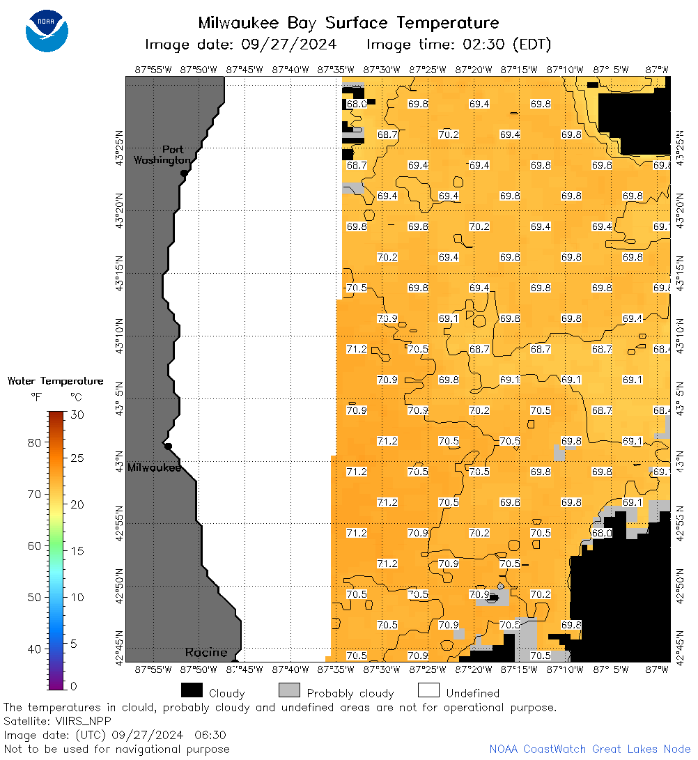 | m65_2024_09_27_0630.png | 27-Sep-2024 12:33 | 40885 | |
 | m65_2024_09_27_0650.png | 27-Sep-2024 13:35 | 53587 | |
 | m65_2024_09_27_0740.png | 27-Sep-2024 13:38 | 53365 | |
 | m65_2024_09_27_0810.png | 27-Sep-2024 13:40 | 52691 | |
 | m65_2024_09_27_0830.png | 27-Sep-2024 16:33 | 47238 | |
 | m65_2024_09_27_0920.png | 27-Sep-2024 13:43 | 20727 | |
 | m65_2024_09_27_0950.png | 27-Sep-2024 16:36 | 20736 | |
 | m65_2024_09_27_1630.png | 27-Sep-2024 21:33 | 20742 | |
 | m65_2024_09_27_1810.png | 27-Sep-2024 21:36 | 21082 | |
 | m65_2024_09_27_1910.png | 27-Sep-2024 22:34 | 21172 | |
 | m65_2024_09_27_1930.png | 27-Sep-2024 22:37 | 22853 | |
 | m65_2024_09_27_1950.png | 27-Sep-2024 22:39 | 24261 | |
 | m65_2024_09_27_2000.png | 27-Sep-2024 23:32 | 24276 | |
 | m65_2024_271.png | 28-Sep-2024 09:26 | 39621 | |