
Easier access to scientific data

Brought to you by NOAA CoastWatch Great Lakes Node
|
ERDDAP
Easier access to scientific data |
|
Brought to you by NOAA CoastWatch Great Lakes Node |
| Dataset Title: | Lake Michigan Milwaukee Bay Surface Temperature Contour Map (2022-present)


|
| Institution: | CoastWatch Great Lakes Node (Dataset ID: LM_NRT_TC_m65) |
| Information: | Summary
| License
| Metadata
| Background | Subset
| Data Access Form
| Make a graph
| Subset
| Data Access Form
| Make a graph
|
![[ICO]](https://apps.glerl.noaa.gov/erddap/images/fileIcons/blank.gif) | Name | Last modified | Size | Description |
|---|---|---|---|---|
![[DIR]](https://apps.glerl.noaa.gov/erddap/images/fileIcons/back.gif) | Parent Directory | - | - | |
![[IMG]](https://apps.glerl.noaa.gov/erddap/images/fileIcons/image2.gif)  | m65_2024_02_29_0100.png | 29-Feb-2024 07:29 | 20728 | |
 | m65_2024_02_29_0110.png | 29-Feb-2024 07:32 | 20728 | |
 | m65_2024_02_29_0150.png | 29-Feb-2024 07:34 | 71800 | |
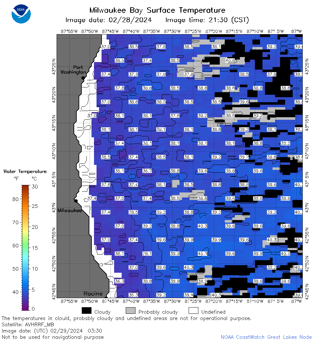 | m65_2024_02_29_0330.png | 29-Feb-2024 07:36 | 57487 | |
 | m65_2024_02_29_0630.png | 29-Feb-2024 18:34 | 51588 | |
 | m65_2024_02_29_0720.png | 29-Feb-2024 18:36 | 54118 | |
 | m65_2024_02_29_0730.png | 29-Feb-2024 18:38 | 24286 | |
 | m65_2024_02_29_0810.png | 29-Feb-2024 18:40 | 60265 | |
 | m65_2024_02_29_0820.png | 29-Feb-2024 18:42 | 21030 | |
 | m65_2024_02_29_0900.png | 29-Feb-2024 18:45 | 36140 | |
 | m65_2024_02_29_0910.png | 29-Feb-2024 18:47 | 24303 | |
 | m65_2024_02_29_1410.png | 29-Feb-2024 18:49 | 20738 | |
 | m65_2024_02_29_1500.png | 29-Feb-2024 18:51 | 42865 | |
 | m65_2024_02_29_1550.png | 29-Feb-2024 18:53 | 46997 | |
 | m65_2024_02_29_1640.png | 29-Feb-2024 19:26 | 47699 | |
 | m65_2024_02_29_1710.png | 29-Feb-2024 19:28 | 22484 | |
 | m65_2024_02_29_1730.png | 29-Feb-2024 19:31 | 20755 | |
 | m65_2024_02_29_1800.png | 29-Feb-2024 20:28 | 42907 | |
 | m65_2024_02_29_1850.png | 29-Feb-2024 21:26 | 44834 | |
 | m65_2024_02_29_1940.png | 29-Feb-2024 21:29 | 50703 | |