
Easier access to scientific data

Brought to you by NOAA CoastWatch Great Lakes Node
|
ERDDAP
Easier access to scientific data |
|
Brought to you by NOAA CoastWatch Great Lakes Node |
| Dataset Title: | Lake Michigan Southern Region Surface Temperature Contour Map (2022-present)


|
| Institution: | CoastWatch Great Lakes Node (Dataset ID: LM_NRT_TC_m5) |
| Information: | Summary
| License
| Metadata
| Background | Subset
| Data Access Form
| Make a graph
| Subset
| Data Access Form
| Make a graph
|
![[ICO]](https://apps.glerl.noaa.gov/erddap/images/fileIcons/blank.gif) | Name | Last modified | Size | Description |
|---|---|---|---|---|
![[DIR]](https://apps.glerl.noaa.gov/erddap/images/fileIcons/back.gif) | Parent Directory | - | - | |
![[IMG]](https://apps.glerl.noaa.gov/erddap/images/fileIcons/image2.gif)  | m5_2024_08_21_0100.png | 21-Aug-2024 16:30 | 23367 | |
 | m5_2024_08_21_0550.png | 21-Aug-2024 16:31 | 23363 | |
 | m5_2024_08_21_0600.png | 21-Aug-2024 16:32 | 23371 | |
 | m5_2024_08_21_0620.png | 21-Aug-2024 16:33 | 26285 | |
 | m5_2024_08_21_0640.png | 21-Aug-2024 16:34 | 23390 | |
 | m5_2024_08_21_0650.png | 21-Aug-2024 16:35 | 51289 | |
 | m5_2024_08_21_0730.png | 21-Aug-2024 16:36 | 23364 | |
 | m5_2024_08_21_0740.png | 21-Aug-2024 16:36 | 48025 | |
 | m5_2024_08_21_0800.png | 21-Aug-2024 16:37 | 28695 | |
 | m5_2024_08_21_0820.png | 21-Aug-2024 16:38 | 23379 | |
 | m5_2024_08_21_0830.png | 21-Aug-2024 16:39 | 57986 | |
 | m5_2024_08_21_0920.png | 21-Aug-2024 16:40 | 25366 | |
 | m5_2024_08_21_0940.png | 21-Aug-2024 16:41 | 23380 | |
 | m5_2024_08_21_1810.png | 21-Aug-2024 22:30 | 55016 | |
 | m5_2024_08_21_1950.png | 22-Aug-2024 03:30 | 34839 | |
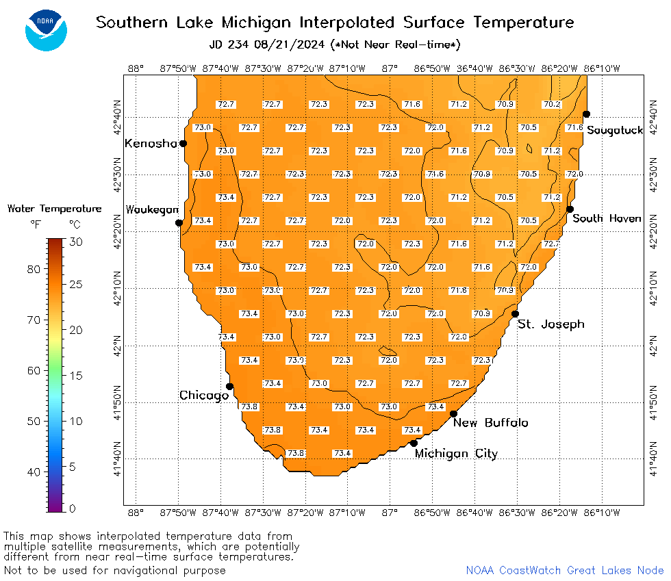 | m5_2024_234.png | 22-Aug-2024 09:10 | 34368 | |