
Easier access to scientific data

Brought to you by NOAA CoastWatch Great Lakes Node
|
ERDDAP
Easier access to scientific data |
|
Brought to you by NOAA CoastWatch Great Lakes Node |
| Dataset Title: | Lake Michigan Southern Region Surface Temperature Contour Map (2022-present)


|
| Institution: | CoastWatch Great Lakes Node (Dataset ID: LM_NRT_TC_m5) |
| Information: | Summary
| License
| Metadata
| Background | Subset
| Data Access Form
| Make a graph
| Subset
| Data Access Form
| Make a graph
|
![[ICO]](https://apps.glerl.noaa.gov/erddap/images/fileIcons/blank.gif) | Name | Last modified | Size | Description |
|---|---|---|---|---|
![[DIR]](https://apps.glerl.noaa.gov/erddap/images/fileIcons/back.gif) | Parent Directory | - | - | |
![[IMG]](https://apps.glerl.noaa.gov/erddap/images/fileIcons/image2.gif)  | m5_2024_02_12_0100.png | 12-Feb-2024 07:26 | 26286 | |
 | m5_2024_02_12_0110.png | 12-Feb-2024 07:28 | 23370 | |
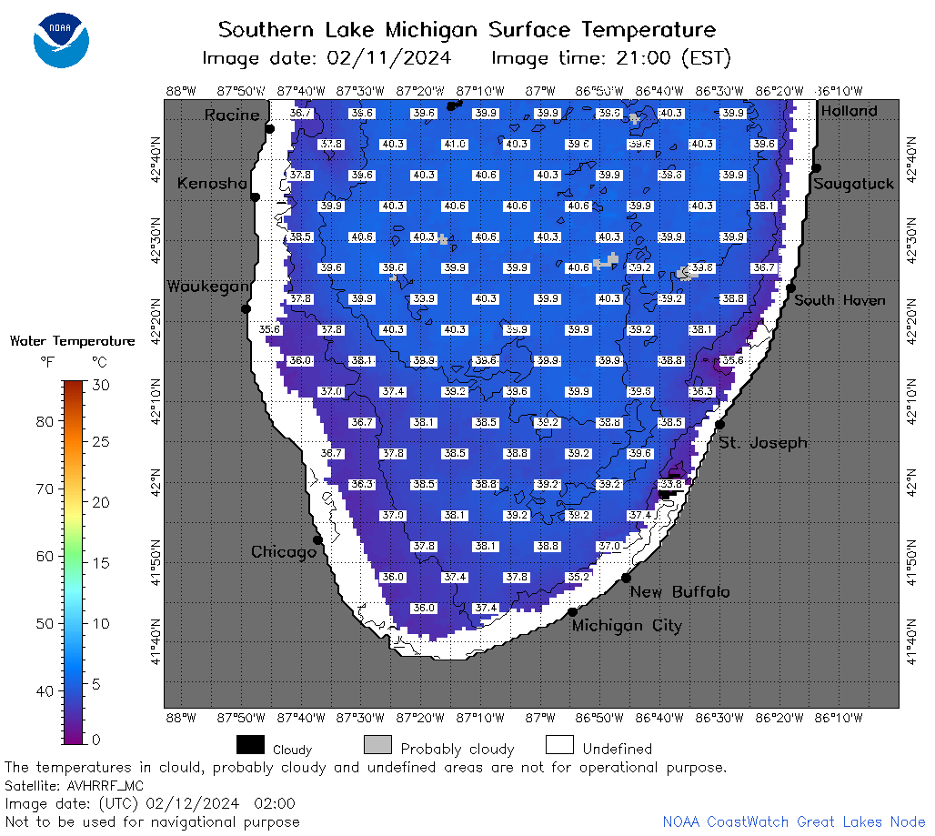 | m5_2024_02_12_0200.png | 12-Feb-2024 07:30 | 56252 | |
 | m5_2024_02_12_0240.png | 12-Feb-2024 07:32 | 73204 | |
 | m5_2024_02_12_0250.png | 12-Feb-2024 07:35 | 23355 | |
 | m5_2024_02_12_0340.png | 12-Feb-2024 07:37 | 48652 | |
 | m5_2024_02_12_0600.png | 12-Feb-2024 10:26 | 23329 | |
 | m5_2024_02_12_0740.png | 12-Feb-2024 12:26 | 54568 | |
 | m5_2024_02_12_0920.png | 12-Feb-2024 17:26 | 25339 | |
 | m5_2024_02_12_1410.png | 12-Feb-2024 18:26 | 23320 | |
 | m5_2024_02_12_1500.png | 12-Feb-2024 18:28 | 43722 | |
 | m5_2024_02_12_1550.png | 12-Feb-2024 19:26 | 47362 | |
 | m5_2024_02_12_1640.png | 12-Feb-2024 20:26 | 46215 | |
 | m5_2024_02_12_1730.png | 12-Feb-2024 22:26 | 57648 | |
 | m5_2024_02_12_1820.png | 12-Feb-2024 21:28 | 52627 | |
 | m5_2024_02_12_1910.png | 13-Feb-2024 00:26 | 51094 | |
 | m5_2024_043.png | 13-Feb-2024 10:13 | 39821 | |