
Easier access to scientific data

Brought to you by NOAA CoastWatch Great Lakes Node
|
ERDDAP
Easier access to scientific data |
|
Brought to you by NOAA CoastWatch Great Lakes Node |
| Dataset Title: | Lake Michigan Central Southern Region Surface Temperature Contour Map (2022- present) 

|
| Institution: | CoastWatch Great Lakes Node (Dataset ID: LM_NRT_TC_m4) |
| Information: | Summary
| License
| Metadata
| Background | Subset
| Data Access Form
| Make a graph
| Subset
| Data Access Form
| Make a graph
|
![[ICO]](https://apps.glerl.noaa.gov/erddap/images/fileIcons/blank.gif) | Name | Last modified | Size | Description |
|---|---|---|---|---|
![[DIR]](https://apps.glerl.noaa.gov/erddap/images/fileIcons/back.gif) | Parent Directory | - | - | |
![[IMG]](https://apps.glerl.noaa.gov/erddap/images/fileIcons/image2.gif)  | m4_2024_09_27_0600.png | 27-Sep-2024 10:30 | 21971 | |
 | m4_2024_09_27_0630.png | 27-Sep-2024 12:30 | 38151 | |
 | m4_2024_09_27_0650.png | 27-Sep-2024 13:30 | 45672 | |
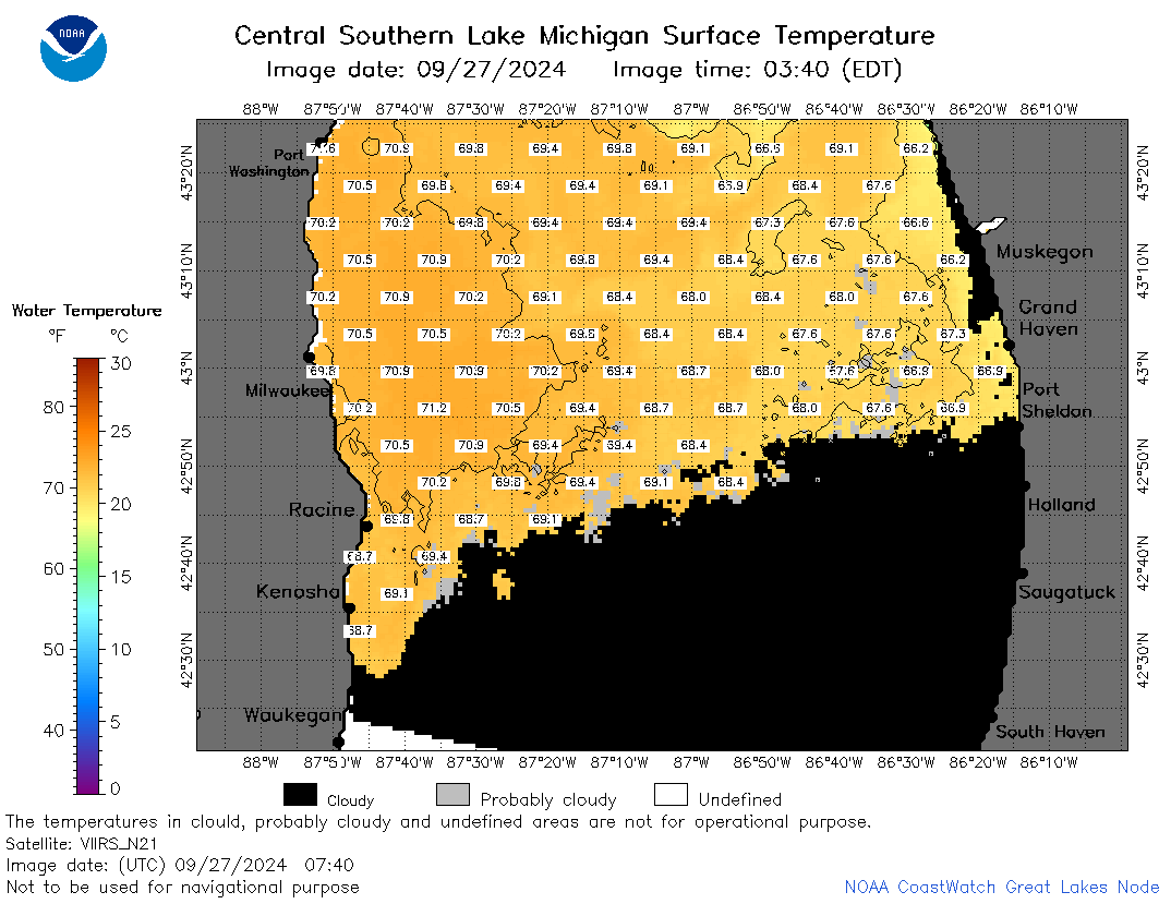 | m4_2024_09_27_0740.png | 27-Sep-2024 13:31 | 48115 | |
 | m4_2024_09_27_0810.png | 27-Sep-2024 13:32 | 44004 | |
 | m4_2024_09_27_0830.png | 27-Sep-2024 16:30 | 39245 | |
 | m4_2024_09_27_0920.png | 27-Sep-2024 13:33 | 21967 | |
 | m4_2024_09_27_0950.png | 27-Sep-2024 16:31 | 21976 | |
 | m4_2024_09_27_1630.png | 27-Sep-2024 21:30 | 21975 | |
 | m4_2024_09_27_1810.png | 27-Sep-2024 21:31 | 22410 | |
 | m4_2024_09_27_1910.png | 27-Sep-2024 22:30 | 24166 | |
 | m4_2024_09_27_1930.png | 27-Sep-2024 22:31 | 22945 | |
 | m4_2024_09_27_1950.png | 27-Sep-2024 22:32 | 24050 | |
 | m4_2024_09_27_2000.png | 27-Sep-2024 23:30 | 24064 | |
 | m4_2024_271.png | 28-Sep-2024 09:10 | 39359 | |