
Easier access to scientific data

Brought to you by NOAA CoastWatch Great Lakes Node
|
ERDDAP
Easier access to scientific data |
|
Brought to you by NOAA CoastWatch Great Lakes Node |
| Dataset Title: | Lake Michigan Central Southern Region Surface Temperature Contour Map (2022- present) 

|
| Institution: | CoastWatch Great Lakes Node (Dataset ID: LM_NRT_TC_m4) |
| Information: | Summary
| License
| Metadata
| Background | Subset
| Data Access Form
| Make a graph
| Subset
| Data Access Form
| Make a graph
|
![[ICO]](https://apps.glerl.noaa.gov/erddap/images/fileIcons/blank.gif) | Name | Last modified | Size | Description |
|---|---|---|---|---|
![[DIR]](https://apps.glerl.noaa.gov/erddap/images/fileIcons/back.gif) | Parent Directory | - | - | |
![[IMG]](https://apps.glerl.noaa.gov/erddap/images/fileIcons/image2.gif)  | m4_2024_05_31_0100.png | 31-May-2024 05:24 | 21956 | |
 | m4_2024_05_31_0150.png | 31-May-2024 06:24 | 29087 | |
 | m4_2024_05_31_0240.png | 31-May-2024 05:25 | 26810 | |
 | m4_2024_05_31_0330.png | 31-May-2024 06:25 | 26878 | |
 | m4_2024_05_31_0720.png | 31-May-2024 13:24 | 61753 | |
 | m4_2024_05_31_0730.png | 31-May-2024 13:25 | 23689 | |
 | m4_2024_05_31_0900.png | 31-May-2024 13:26 | 24048 | |
 | m4_2024_05_31_0910.png | 31-May-2024 13:27 | 24051 | |
 | m4_2024_05_31_1400.png | 31-May-2024 17:24 | 21968 | |
 | m4_2024_05_31_1500.png | 31-May-2024 19:24 | 31775 | |
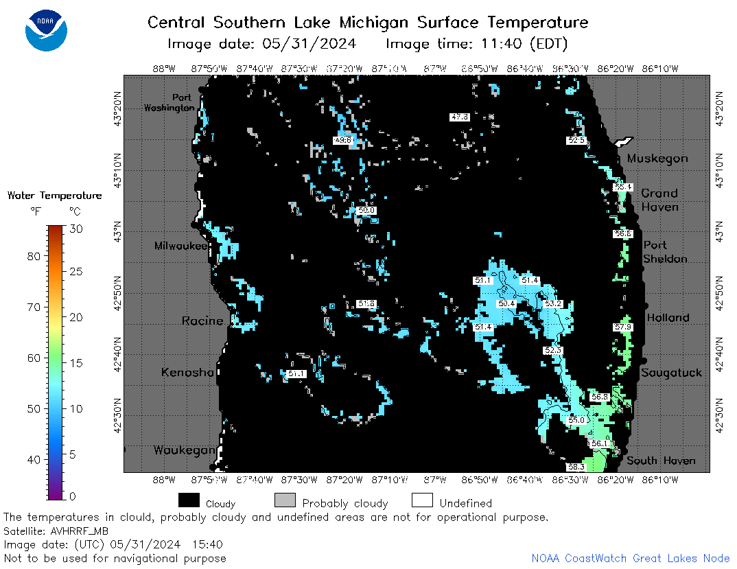 | m4_2024_05_31_1540.png | 31-May-2024 19:25 | 38294 | |
 | m4_2024_05_31_1550.png | 31-May-2024 19:26 | 24060 | |
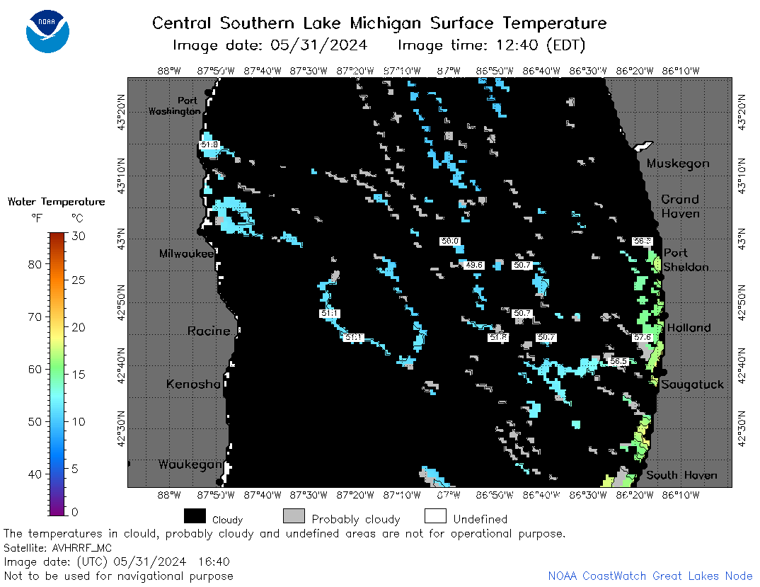 | m4_2024_05_31_1640.png | 31-May-2024 20:24 | 34924 | |
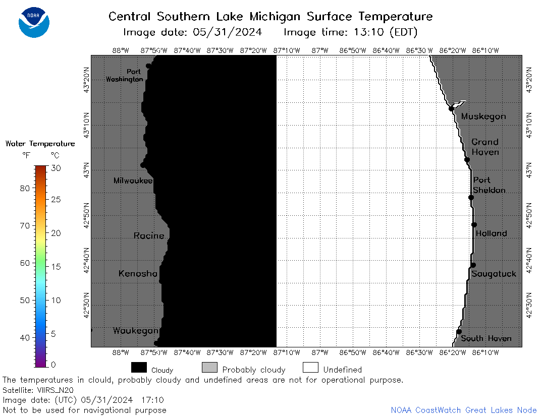 | m4_2024_05_31_1710.png | 31-May-2024 23:24 | 24929 | |
 | m4_2024_05_31_1720.png | 31-May-2024 20:25 | 21963 | |
 | m4_2024_05_31_1850.png | 31-May-2024 23:25 | 34481 | |
 | m4_2024_152.png | 01-Jun-2024 09:10 | 45227 | |