
Easier access to scientific data

Brought to you by NOAA CoastWatch Great Lakes Node
|
ERDDAP
Easier access to scientific data |
|
Brought to you by NOAA CoastWatch Great Lakes Node |
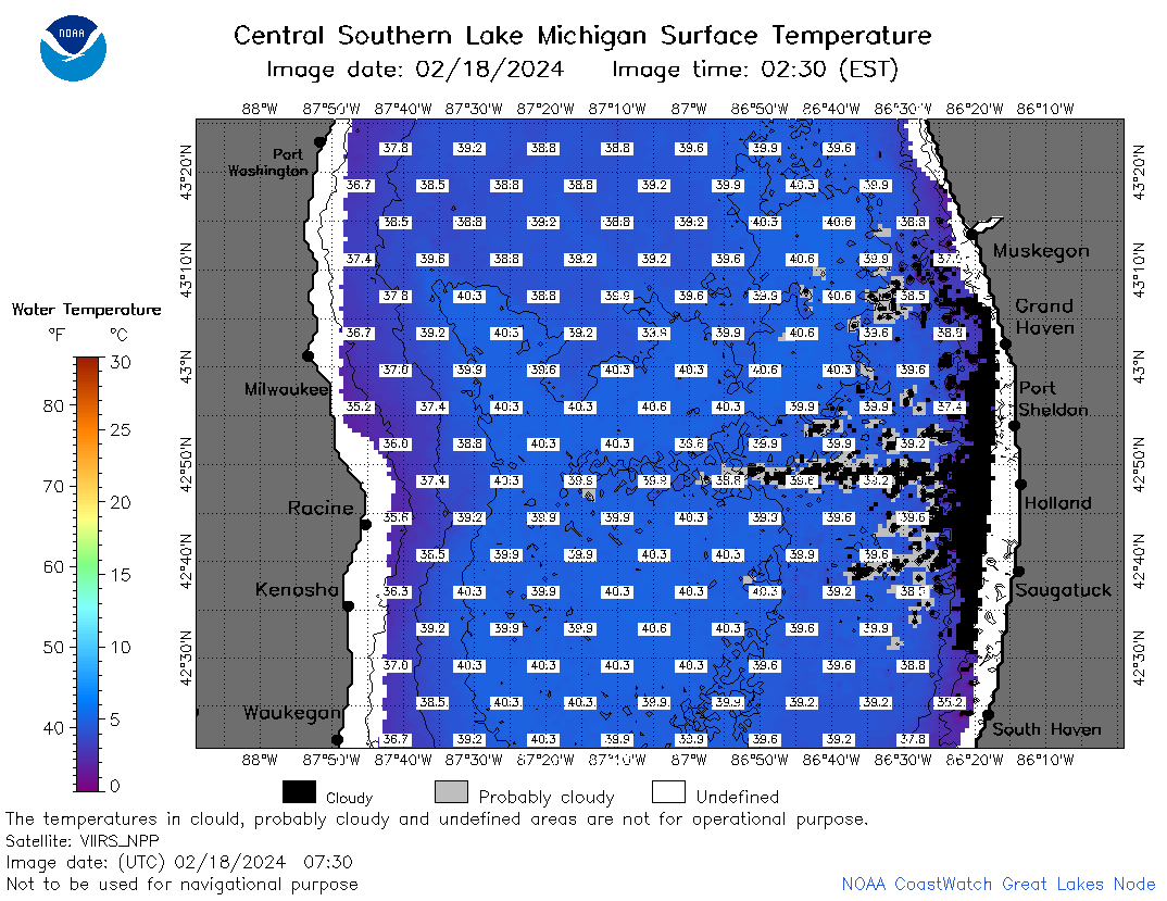
| Dataset Title: | Lake Michigan Central Southern Region Surface Temperature Contour Map (2022- present) 

|
| Institution: | CoastWatch Great Lakes Node (Dataset ID: LM_NRT_TC_m4) |
| Information: | Summary
| License
| Metadata
| Background | Subset
| Data Access Form
| Make a graph
| Subset
| Data Access Form
| Make a graph
|
![[ICO]](https://apps.glerl.noaa.gov/erddap/images/fileIcons/blank.gif) | Name | Last modified | Size | Description |
|---|---|---|---|---|
![[DIR]](https://apps.glerl.noaa.gov/erddap/images/fileIcons/back.gif) | Parent Directory | - | - | |
![[IMG]](https://apps.glerl.noaa.gov/erddap/images/fileIcons/image2.gif)  | m4_2024_02_18_0130.png | 18-Feb-2024 06:26 | 29237 | |
 | m4_2024_02_18_0220.png | 18-Feb-2024 06:28 | 52638 | |
 | m4_2024_02_18_0310.png | 18-Feb-2024 06:30 | 60854 | |
 | m4_2024_02_18_0640.png | 18-Feb-2024 10:26 | 67118 | |
 | m4_2024_02_18_0730.png | 18-Feb-2024 12:26 | 68569 | |
 | m4_2024_02_18_0820.png | 18-Feb-2024 11:26 | 65161 | |
 | m4_2024_02_18_0910.png | 18-Feb-2024 17:26 | 24044 | |
 | m4_2024_02_18_1430.png | 18-Feb-2024 17:28 | 21982 | |
 | m4_2024_02_18_1440.png | 18-Feb-2024 17:30 | 42806 | |
 | m4_2024_02_18_1530.png | 18-Feb-2024 19:26 | 55342 | |
 | m4_2024_02_18_1610.png | 18-Feb-2024 19:28 | 21960 | |
 | m4_2024_02_18_1620.png | 18-Feb-2024 19:30 | 50325 | |
 | m4_2024_02_18_1710.png | 18-Feb-2024 21:26 | 24048 | |
 | m4_2024_02_18_1720.png | 18-Feb-2024 21:28 | 21958 | |
 | m4_2024_02_18_1800.png | 18-Feb-2024 20:28 | 46827 | |
 | m4_2024_02_18_1810.png | 18-Feb-2024 21:30 | 21964 | |
 | m4_2024_02_18_1850.png | 18-Feb-2024 22:25 | 49519 | |
 | m4_2024_02_18_1940.png | 18-Feb-2024 22:28 | 42301 | |
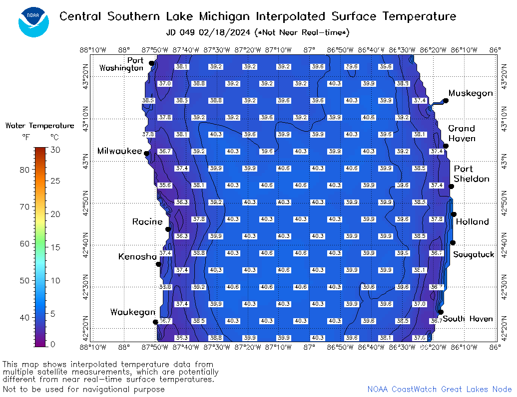 | m4_2024_049.png | 19-Feb-2024 10:12 | 41947 | |