
Easier access to scientific data

Brought to you by NOAA CoastWatch Great Lakes Node
|
ERDDAP
Easier access to scientific data |
|
Brought to you by NOAA CoastWatch Great Lakes Node |
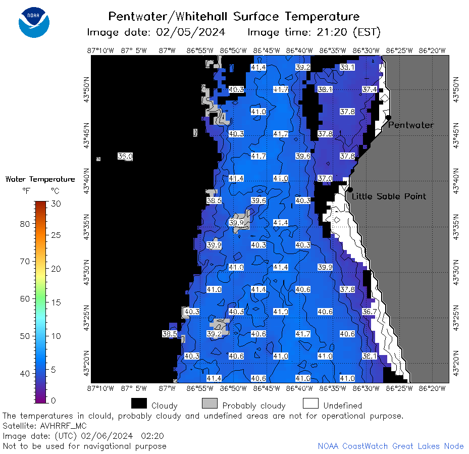
| Dataset Title: | Lake Michigan Pentwater/Whitehall Surface Temperature Contour Map (2022- present) 

|
| Institution: | CoastWatch Great Lakes Node (Dataset ID: LM_NRT_TC_m32) |
| Information: | Summary
| License
| Metadata
| Background | Subset
| Data Access Form
| Make a graph
| Subset
| Data Access Form
| Make a graph
|
![[ICO]](https://apps.glerl.noaa.gov/erddap/images/fileIcons/blank.gif) | Name | Last modified | Size | Description |
|---|---|---|---|---|
![[DIR]](https://apps.glerl.noaa.gov/erddap/images/fileIcons/back.gif) | Parent Directory | - | - | |
![[IMG]](https://apps.glerl.noaa.gov/erddap/images/fileIcons/image2.gif)  | m32_2024_02_06_0130.png | 06-Feb-2024 06:36 | 44666 | |
 | m32_2024_02_06_0220.png | 06-Feb-2024 06:43 | 43426 | |
 | m32_2024_02_06_0310.png | 06-Feb-2024 06:49 | 33576 | |
 | m32_2024_02_06_0610.png | 06-Feb-2024 10:33 | 18667 | |
 | m32_2024_02_06_0620.png | 06-Feb-2024 10:40 | 18306 | |
 | m32_2024_02_06_0750.png | 06-Feb-2024 10:46 | 18549 | |
 | m32_2024_02_06_0800.png | 06-Feb-2024 10:52 | 19032 | |
 | m32_2024_02_06_1430.png | 06-Feb-2024 18:31 | 18105 | |
 | m32_2024_02_06_1440.png | 06-Feb-2024 18:37 | 19226 | |
 | m32_2024_02_06_1520.png | 06-Feb-2024 18:44 | 19039 | |
 | m32_2024_02_06_1530.png | 06-Feb-2024 18:50 | 18126 | |
 | m32_2024_02_06_1610.png | 06-Feb-2024 19:35 | 18076 | |
 | m32_2024_02_06_1620.png | 06-Feb-2024 19:41 | 18998 | |
 | m32_2024_02_06_1700.png | 06-Feb-2024 19:48 | 18567 | |
 | m32_2024_02_06_1740.png | 06-Feb-2024 19:54 | 18996 | |
 | m32_2024_02_06_1920.png | 07-Feb-2024 00:31 | 18992 | |
 | m32_2024_037.png | 07-Feb-2024 10:40 | 32943 | |