
Easier access to scientific data

Brought to you by NOAA CoastWatch Great Lakes Node
|
ERDDAP
Easier access to scientific data |
|
Brought to you by NOAA CoastWatch Great Lakes Node |
| Dataset Title: | Lake Erie Ashtabula Surface Temperature Contour Map (2022-present)


|
| Institution: | CoastWatch Great Lakes Node (Dataset ID: LE_NRT_TC_e22) |
| Information: | Summary
| License
| Metadata
| Background | Subset
| Data Access Form
| Make a graph
| Subset
| Data Access Form
| Make a graph
|
![[ICO]](https://apps.glerl.noaa.gov/erddap/images/fileIcons/blank.gif) | Name | Last modified | Size | Description |
|---|---|---|---|---|
![[DIR]](https://apps.glerl.noaa.gov/erddap/images/fileIcons/back.gif) | Parent Directory | - | - | |
![[IMG]](https://apps.glerl.noaa.gov/erddap/images/fileIcons/image2.gif)  | e22_2023_10_01_0130.png | 01-Oct-2023 05:39 | 33937 | |
 | e22_2023_10_01_0210.png | 01-Oct-2023 05:47 | 17300 | |
 | e22_2023_10_01_0220.png | 01-Oct-2023 05:54 | 41185 | |
 | e22_2023_10_01_0310.png | 01-Oct-2023 06:02 | 31806 | |
 | e22_2023_10_01_0610.png | 01-Oct-2023 10:34 | 17291 | |
 | e22_2023_10_01_0620.png | 01-Oct-2023 10:41 | 39267 | |
 | e22_2023_10_01_0750.png | 01-Oct-2023 10:48 | 17241 | |
 | e22_2023_10_01_0800.png | 01-Oct-2023 10:55 | 33062 | |
 | e22_2023_10_01_1430.png | 01-Oct-2023 18:32 | 31743 | |
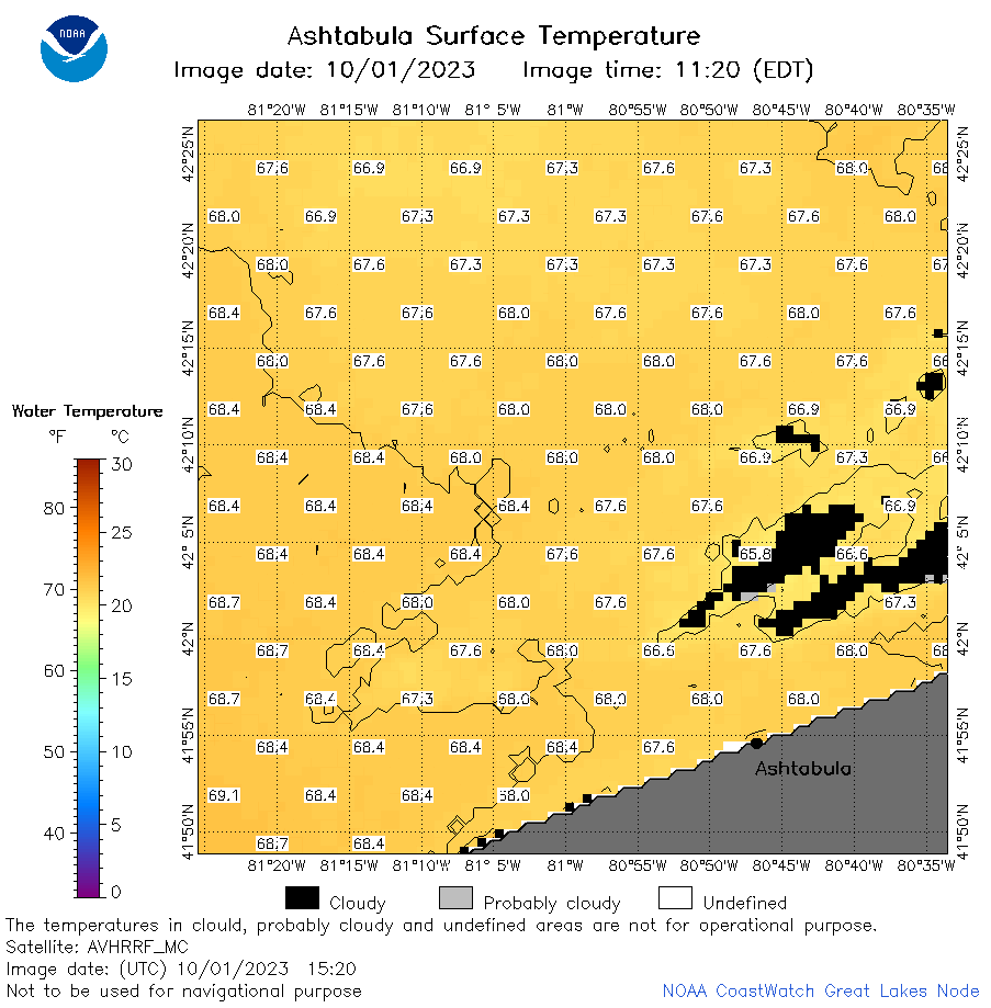 | e22_2023_10_01_1520.png | 01-Oct-2023 18:40 | 36676 | |
 | e22_2023_10_01_1530.png | 01-Oct-2023 18:47 | 17302 | |
 | e22_2023_10_01_1610.png | 01-Oct-2023 18:55 | 32419 | |
 | e22_2023_10_01_1700.png | 01-Oct-2023 20:32 | 17212 | |
 | e22_2023_10_01_1710.png | 01-Oct-2023 20:39 | 17197 | |
 | e22_2023_10_01_1740.png | 01-Oct-2023 19:37 | 30563 | |
 | e22_2023_10_01_1830.png | 01-Oct-2023 20:47 | 32006 | |
 | e22_2023_10_01_1920.png | 01-Oct-2023 23:32 | 34809 | |
 | e22_2023_274.png | 02-Oct-2023 10:13 | 26796 | |