
Easier access to scientific data

Brought to you by NOAA CoastWatch Great Lakes Node
|
ERDDAP
Easier access to scientific data |
|
Brought to you by NOAA CoastWatch Great Lakes Node |
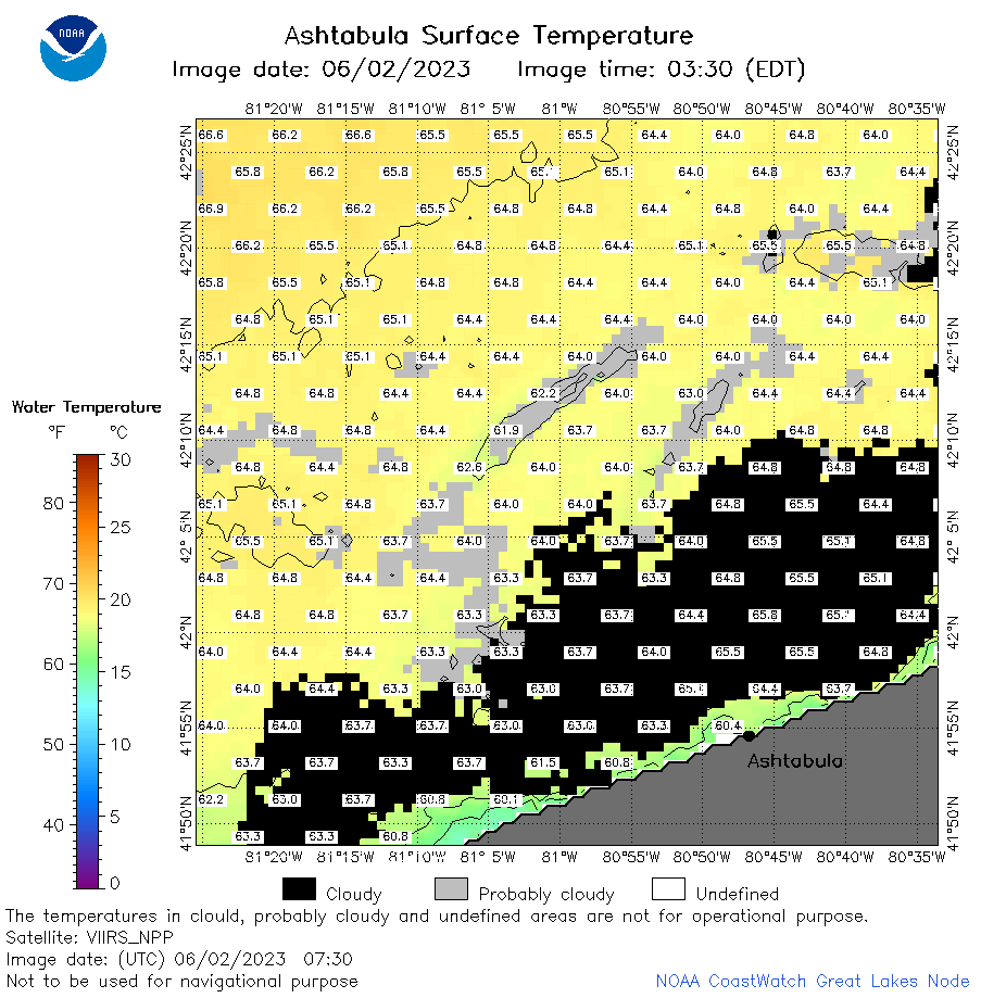
| Dataset Title: | Lake Erie Ashtabula Surface Temperature Contour Map (2022-present)


|
| Institution: | CoastWatch Great Lakes Node (Dataset ID: LE_NRT_TC_e22) |
| Information: | Summary
| License
| Metadata
| Background | Subset
| Data Access Form
| Make a graph
| Subset
| Data Access Form
| Make a graph
|
![[ICO]](https://apps.glerl.noaa.gov/erddap/images/fileIcons/blank.gif) | Name | Last modified | Size | Description |
|---|---|---|---|---|
![[DIR]](https://apps.glerl.noaa.gov/erddap/images/fileIcons/back.gif) | Parent Directory | - | - | |
![[IMG]](https://apps.glerl.noaa.gov/erddap/images/fileIcons/image2.gif)  | e22_2023_06_02_0130.png | 02-Jun-2023 05:38 | 22787 | |
 | e22_2023_06_02_0220.png | 02-Jun-2023 05:49 | 23132 | |
 | e22_2023_06_02_0310.png | 02-Jun-2023 05:57 | 22877 | |
 | e22_2023_06_02_0630.png | 02-Jun-2023 09:33 | 40579 | |
 | e22_2023_06_02_0730.png | 02-Jun-2023 11:45 | 40546 | |
 | e22_2023_06_02_0810.png | 02-Jun-2023 11:51 | 48877 | |
 | e22_2023_06_02_1440.png | 02-Jun-2023 19:46 | 29586 | |
 | e22_2023_06_02_1530.png | 02-Jun-2023 19:54 | 26621 | |
 | e22_2023_06_02_1620.png | 02-Jun-2023 20:06 | 29917 | |
 | e22_2023_06_02_1710.png | 02-Jun-2023 20:13 | 24604 | |
 | e22_2023_06_02_1800.png | 02-Jun-2023 20:21 | 30450 | |
 | e22_2023_06_02_1850.png | 02-Jun-2023 21:33 | 29944 | |
 | e22_2023_153.png | 03-Jun-2023 10:14 | 31132 | |