
Easier access to scientific data

Brought to you by NOAA CoastWatch Great Lakes Node
|
ERDDAP
Easier access to scientific data |
|
Brought to you by NOAA CoastWatch Great Lakes Node |
| Dataset Title: | Lake Erie Ashtabula Surface Temperature Contour Map (2022-present)


|
| Institution: | CoastWatch Great Lakes Node (Dataset ID: LE_NRT_TC_e22) |
| Information: | Summary
| License
| Metadata
| Background | Subset
| Data Access Form
| Make a graph
| Subset
| Data Access Form
| Make a graph
|
![[ICO]](https://apps.glerl.noaa.gov/erddap/images/fileIcons/blank.gif) | Name | Last modified | Size | Description |
|---|---|---|---|---|
![[DIR]](https://apps.glerl.noaa.gov/erddap/images/fileIcons/back.gif) | Parent Directory | - | - | |
![[IMG]](https://apps.glerl.noaa.gov/erddap/images/fileIcons/image2.gif)  | e22_2023_05_09_0130.png | 09-May-2023 05:35 | 20330 | |
 | e22_2023_05_09_0220.png | 09-May-2023 05:43 | 20118 | |
 | e22_2023_05_09_0310.png | 09-May-2023 05:50 | 19781 | |
 | e22_2023_05_09_0640.png | 09-May-2023 10:39 | 19783 | |
 | e22_2023_05_09_0720.png | 09-May-2023 10:46 | 19862 | |
 | e22_2023_05_09_0820.png | 09-May-2023 11:39 | 19790 | |
 | e22_2023_05_09_1430.png | 09-May-2023 18:32 | 37062 | |
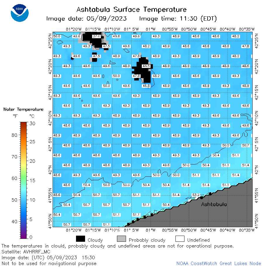 | e22_2023_05_09_1530.png | 09-May-2023 18:43 | 36785 | |
 | e22_2023_05_09_1610.png | 09-May-2023 18:50 | 38671 | |
 | e22_2023_05_09_1710.png | 09-May-2023 19:36 | 45172 | |
 | e22_2023_05_09_1800.png | 09-May-2023 20:42 | 39745 | |
 | e22_2023_05_09_1850.png | 09-May-2023 21:36 | 41072 | |
 | e22_2023_129.png | 10-May-2023 10:12 | 30177 | |