
Easier access to scientific data

Brought to you by NOAA CoastWatch Great Lakes Node
|
ERDDAP
Easier access to scientific data |
|
Brought to you by NOAA CoastWatch Great Lakes Node |
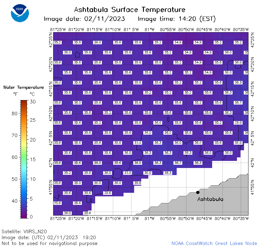
| Dataset Title: | Lake Erie Ashtabula Surface Temperature Contour Map (2022-present)


|
| Institution: | CoastWatch Great Lakes Node (Dataset ID: LE_NRT_TC_e22) |
| Information: | Summary
| License
| Metadata
| Background | Subset
| Data Access Form
| Make a graph
| Subset
| Data Access Form
| Make a graph
|
![[ICO]](https://apps.glerl.noaa.gov/erddap/images/fileIcons/blank.gif) | Name | Last modified | Size | Description |
|---|---|---|---|---|
![[DIR]](https://apps.glerl.noaa.gov/erddap/images/fileIcons/back.gif) | Parent Directory | - | - | |
![[IMG]](https://apps.glerl.noaa.gov/erddap/images/fileIcons/image2.gif)  | e22_2023_02_11_0220.png | 11-Feb-2023 19:39 | 15497 | |
 | e22_2023_02_11_0310.png | 11-Feb-2023 19:42 | 16789 | |
 | e22_2023_02_11_0610.png | 11-Feb-2023 19:44 | 23185 | |
 | e22_2023_02_11_0710.png | 11-Feb-2023 19:47 | 20890 | |
 | e22_2023_02_11_0750.png | 11-Feb-2023 19:50 | 21040 | |
 | e22_2023_02_11_0800.png | 11-Feb-2023 19:53 | 17407 | |
 | e22_2023_02_11_1430.png | 11-Feb-2023 19:58 | 22789 | |
 | e22_2023_02_11_1530.png | 11-Feb-2023 20:03 | 26817 | |
 | e22_2023_02_11_1610.png | 11-Feb-2023 20:06 | 25296 | |
 | e22_2023_02_11_1740.png | 11-Feb-2023 20:10 | 25869 | |
 | e22_2023_02_11_1830.png | 11-Feb-2023 20:31 | 25430 | |
 | e22_2023_02_11_1920.png | 11-Feb-2023 21:29 | 26453 | |
 | e22_2023_042.png | 12-Feb-2023 11:12 | 25110 | |