
Easier access to scientific data

Brought to you by NOAA CoastWatch Great Lakes Node
|
ERDDAP
Easier access to scientific data |
|
Brought to you by NOAA CoastWatch Great Lakes Node |
| Dataset Title: | Lake Erie Sandusky Surface Temperature Contour Map (2022-present)


|
| Institution: | CoastWatch Great Lakes Node (Dataset ID: LE_NRT_TC_e12) |
| Information: | Summary
| License
| Metadata
| Background | Subset
| Data Access Form
| Make a graph
| Subset
| Data Access Form
| Make a graph
|
![[ICO]](https://apps.glerl.noaa.gov/erddap/images/fileIcons/blank.gif) | Name | Last modified | Size | Description |
|---|---|---|---|---|
![[DIR]](https://apps.glerl.noaa.gov/erddap/images/fileIcons/back.gif) | Parent Directory | - | - | |
![[IMG]](https://apps.glerl.noaa.gov/erddap/images/fileIcons/image2.gif)  | e12_2024_05_02_0100.png | 02-May-2024 06:30 | 18206 | |
 | e12_2024_05_02_0150.png | 02-May-2024 06:32 | 19928 | |
 | e12_2024_05_02_0240.png | 02-May-2024 06:35 | 24397 | |
 | e12_2024_05_02_0330.png | 02-May-2024 06:37 | 19334 | |
 | e12_2024_05_02_0600.png | 02-May-2024 19:28 | 18159 | |
 | e12_2024_05_02_0630.png | 02-May-2024 19:31 | 36160 | |
 | e12_2024_05_02_1400.png | 02-May-2024 18:27 | 18150 | |
 | e12_2024_05_02_1410.png | 02-May-2024 18:30 | 18143 | |
 | e12_2024_05_02_1500.png | 02-May-2024 18:32 | 31339 | |
 | e12_2024_05_02_1540.png | 02-May-2024 18:35 | 18876 | |
 | e12_2024_05_02_1550.png | 02-May-2024 18:37 | 30805 | |
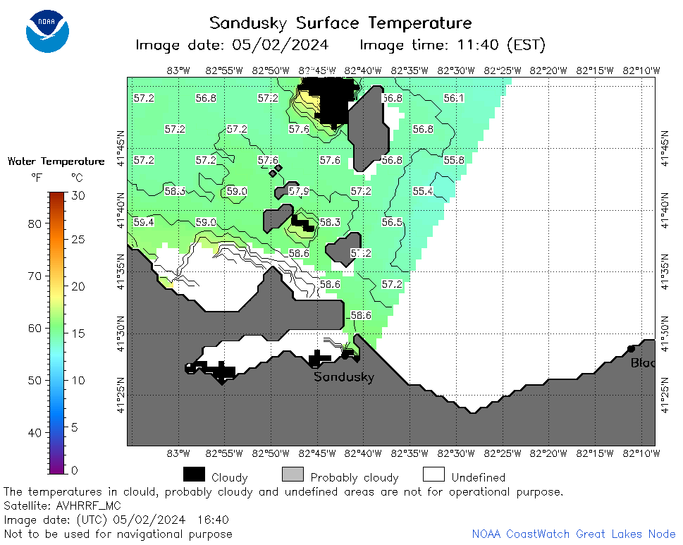 | e12_2024_05_02_1640.png | 02-May-2024 19:33 | 29254 | |
 | e12_2024_05_02_1720.png | 02-May-2024 19:36 | 18144 | |
 | e12_2024_123.png | 03-May-2024 11:30 | 35526 | |