
Easier access to scientific data

Brought to you by NOAA CoastWatch Great Lakes Node
|
ERDDAP
Easier access to scientific data |
|
Brought to you by NOAA CoastWatch Great Lakes Node |
| Dataset Title: | Lake Erie Sandusky Surface Temperature Contour Map (2022-present)


|
| Institution: | CoastWatch Great Lakes Node (Dataset ID: LE_NRT_TC_e12) |
| Information: | Summary
| License
| Metadata
| Background | Subset
| Data Access Form
| Make a graph
| Subset
| Data Access Form
| Make a graph
|
![[ICO]](https://apps.glerl.noaa.gov/erddap/images/fileIcons/blank.gif) | Name | Last modified | Size | Description |
|---|---|---|---|---|
![[DIR]](https://apps.glerl.noaa.gov/erddap/images/fileIcons/back.gif) | Parent Directory | - | - | |
![[IMG]](https://apps.glerl.noaa.gov/erddap/images/fileIcons/image2.gif)  | e12_2023_06_29_0120.png | 29-Jun-2023 05:36 | 35529 | |
 | e12_2023_06_29_0210.png | 29-Jun-2023 05:43 | 33497 | |
 | e12_2023_06_29_0300.png | 29-Jun-2023 05:56 | 33461 | |
 | e12_2023_06_29_0630.png | 29-Jun-2023 09:32 | 37618 | |
 | e12_2023_06_29_0720.png | 29-Jun-2023 11:35 | 36001 | |
 | e12_2023_06_29_0810.png | 29-Jun-2023 11:43 | 36459 | |
 | e12_2023_06_29_1430.png | 29-Jun-2023 18:34 | 23178 | |
 | e12_2023_06_29_1520.png | 29-Jun-2023 18:42 | 27344 | |
 | e12_2023_06_29_1610.png | 29-Jun-2023 20:38 | 25252 | |
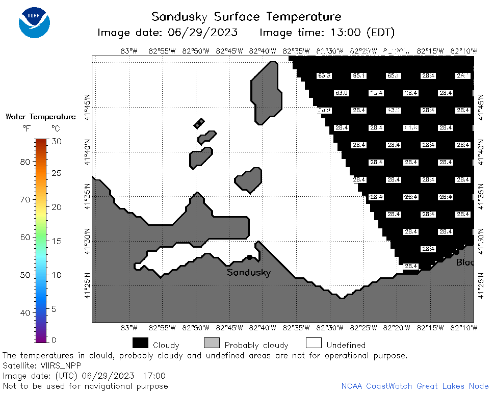 | e12_2023_06_29_1700.png | 29-Jun-2023 20:52 | 22030 | |
 | e12_2023_06_29_1750.png | 29-Jun-2023 21:05 | 26688 | |
 | e12_2023_06_29_1840.png | 29-Jun-2023 21:13 | 32577 | |
 | e12_2023_06_29_1930.png | 29-Jun-2023 21:38 | 22645 | |
 | e12_2023_180.png | 30-Jun-2023 10:09 | 27647 | |