
Easier access to scientific data

Brought to you by NOAA CoastWatch Great Lakes Node
|
ERDDAP
Easier access to scientific data |
|
Brought to you by NOAA CoastWatch Great Lakes Node |
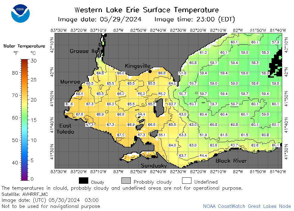
| Dataset Title: | Lake Erie Western Region Surface Temperature Contour Map (2022-present)


|
| Institution: | CoastWatch Great Lakes Node (Dataset ID: LE_NRT_TC_e1) |
| Information: | Summary
| License
| Metadata
| Background | Subset
| Data Access Form
| Make a graph
| Subset
| Data Access Form
| Make a graph
|
![[ICO]](https://apps.glerl.noaa.gov/erddap/images/fileIcons/blank.gif) | Name | Last modified | Size | Description |
|---|---|---|---|---|
![[DIR]](https://apps.glerl.noaa.gov/erddap/images/fileIcons/back.gif) | Parent Directory | - | - | |
![[IMG]](https://apps.glerl.noaa.gov/erddap/images/fileIcons/image2.gif)  | e1_2024_05_30_0120.png | 30-May-2024 13:24 | 44545 | |
 | e1_2024_05_30_0210.png | 30-May-2024 13:25 | 44957 | |
 | e1_2024_05_30_0300.png | 30-May-2024 13:26 | 40907 | |
 | e1_2024_05_30_0350.png | 30-May-2024 13:27 | 19506 | |
 | e1_2024_05_30_0600.png | 30-May-2024 13:28 | 20314 | |
 | e1_2024_05_30_0720.png | 30-May-2024 13:29 | 40599 | |
 | e1_2024_05_30_0740.png | 30-May-2024 13:30 | 41398 | |
 | e1_2024_05_30_0900.png | 30-May-2024 13:31 | 22234 | |
 | e1_2024_05_30_0920.png | 30-May-2024 13:32 | 19486 | |
 | e1_2024_05_30_1420.png | 30-May-2024 18:24 | 36070 | |
 | e1_2024_05_30_1520.png | 30-May-2024 19:24 | 41774 | |
 | e1_2024_05_30_1600.png | 30-May-2024 19:25 | 41349 | |
 | e1_2024_05_30_1610.png | 30-May-2024 19:26 | 21199 | |
 | e1_2024_05_30_1700.png | 30-May-2024 21:24 | 22247 | |
 | e1_2024_05_30_1730.png | 30-May-2024 21:25 | 45208 | |
 | e1_2024_05_30_1910.png | 30-May-2024 22:24 | 43900 | |
 | e1_2024_151.png | 31-May-2024 09:11 | 30851 | |