
Easier access to scientific data

Brought to you by NOAA CoastWatch Great Lakes Node
|
ERDDAP
Easier access to scientific data |
|
Brought to you by NOAA CoastWatch Great Lakes Node |
| Dataset Title: | Lake Erie Western Region Surface Temperature Contour Map (2022-present)


|
| Institution: | CoastWatch Great Lakes Node (Dataset ID: LE_NRT_TC_e1) |
| Information: | Summary
| License
| Metadata
| Background | Subset
| Data Access Form
| Make a graph
| Subset
| Data Access Form
| Make a graph
|
![[ICO]](https://apps.glerl.noaa.gov/erddap/images/fileIcons/blank.gif) | Name | Last modified | Size | Description |
|---|---|---|---|---|
![[DIR]](https://apps.glerl.noaa.gov/erddap/images/fileIcons/back.gif) | Parent Directory | - | - | |
![[IMG]](https://apps.glerl.noaa.gov/erddap/images/fileIcons/image2.gif)  | e1_2024_04_23_0130.png | 23-Apr-2024 06:24 | 40355 | |
 | e1_2024_04_23_0140.png | 23-Apr-2024 06:25 | 21080 | |
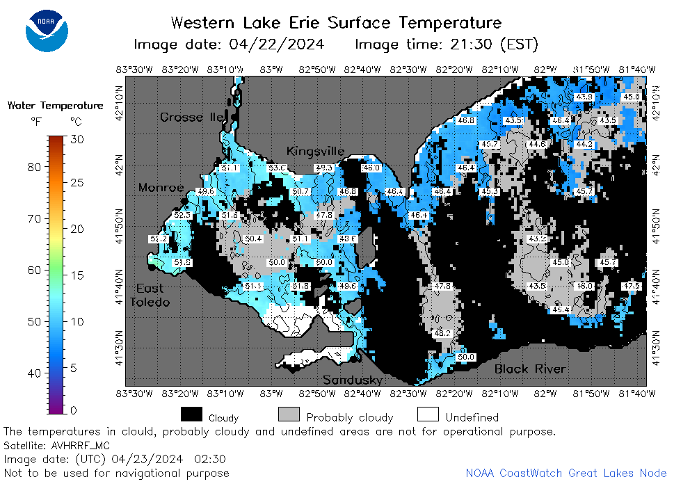 | e1_2024_04_23_0230.png | 23-Apr-2024 06:26 | 44882 | |
 | e1_2024_04_23_0310.png | 23-Apr-2024 06:27 | 23259 | |
 | e1_2024_04_23_0320.png | 23-Apr-2024 06:28 | 23097 | |
 | e1_2024_04_23_0600.png | 23-Apr-2024 09:24 | 20320 | |
 | e1_2024_04_23_0710.png | 23-Apr-2024 14:24 | 27633 | |
 | e1_2024_04_23_0740.png | 23-Apr-2024 12:24 | 23159 | |
 | e1_2024_04_23_0850.png | 23-Apr-2024 21:24 | 22275 | |
 | e1_2024_04_23_0920.png | 23-Apr-2024 21:25 | 19493 | |
 | e1_2024_04_23_1440.png | 23-Apr-2024 18:24 | 20594 | |
 | e1_2024_04_23_1620.png | 23-Apr-2024 21:26 | 20778 | |
 | e1_2024_04_23_1700.png | 23-Apr-2024 21:27 | 21183 | |
 | e1_2024_04_23_1710.png | 23-Apr-2024 21:28 | 19491 | |
 | e1_2024_04_23_1720.png | 23-Apr-2024 21:29 | 20767 | |
 | e1_2024_04_23_1840.png | 24-Apr-2024 00:24 | 20713 | |
 | e1_2024_04_23_1900.png | 23-Apr-2024 22:24 | 20689 | |