
Easier access to scientific data

Brought to you by NOAA CoastWatch Great Lakes Node
|
ERDDAP
Easier access to scientific data |
|
Brought to you by NOAA CoastWatch Great Lakes Node |
| Dataset Title: | Lake Erie Western Region Surface Temperature Contour Map (2022-present)


|
| Institution: | CoastWatch Great Lakes Node (Dataset ID: LE_NRT_TC_e1) |
| Information: | Summary
| License
| Metadata
| Background | Subset
| Data Access Form
| Make a graph
| Subset
| Data Access Form
| Make a graph
|
![[ICO]](https://apps.glerl.noaa.gov/erddap/images/fileIcons/blank.gif) | Name | Last modified | Size | Description |
|---|---|---|---|---|
![[DIR]](https://apps.glerl.noaa.gov/erddap/images/fileIcons/back.gif) | Parent Directory | - | - | |
![[IMG]](https://apps.glerl.noaa.gov/erddap/images/fileIcons/image2.gif)  | e1_2024_02_29_0100.png | 29-Feb-2024 07:24 | 20321 | |
 | e1_2024_02_29_0110.png | 29-Feb-2024 07:25 | 19487 | |
 | e1_2024_02_29_0150.png | 29-Feb-2024 07:26 | 23620 | |
 | e1_2024_02_29_0330.png | 29-Feb-2024 07:27 | 22283 | |
 | e1_2024_02_29_0630.png | 29-Feb-2024 18:24 | 32138 | |
 | e1_2024_02_29_0720.png | 29-Feb-2024 18:25 | 33198 | |
 | e1_2024_02_29_0730.png | 29-Feb-2024 18:26 | 19502 | |
 | e1_2024_02_29_0810.png | 29-Feb-2024 18:27 | 29481 | |
 | e1_2024_02_29_0820.png | 29-Feb-2024 18:28 | 22245 | |
 | e1_2024_02_29_0900.png | 29-Feb-2024 18:29 | 19502 | |
 | e1_2024_02_29_0910.png | 29-Feb-2024 18:30 | 19518 | |
 | e1_2024_02_29_1410.png | 29-Feb-2024 18:30 | 21107 | |
 | e1_2024_02_29_1500.png | 29-Feb-2024 18:31 | 39973 | |
 | e1_2024_02_29_1550.png | 29-Feb-2024 19:24 | 36323 | |
 | e1_2024_02_29_1640.png | 29-Feb-2024 20:24 | 22376 | |
 | e1_2024_02_29_1710.png | 29-Feb-2024 20:25 | 35718 | |
 | e1_2024_02_29_1730.png | 29-Feb-2024 20:26 | 19520 | |
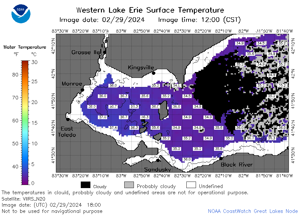 | e1_2024_02_29_1800.png | 29-Feb-2024 21:24 | 35078 | |
 | e1_2024_02_29_1850.png | 29-Feb-2024 22:24 | 35789 | |
 | e1_2024_02_29_1940.png | 29-Feb-2024 22:25 | 22305 | |
 | e1_2024_060.png | 01-Mar-2024 11:11 | 31424 | |