
Easier access to scientific data

Brought to you by NOAA CoastWatch Great Lakes Node
|
ERDDAP
Easier access to scientific data |
|
Brought to you by NOAA CoastWatch Great Lakes Node |
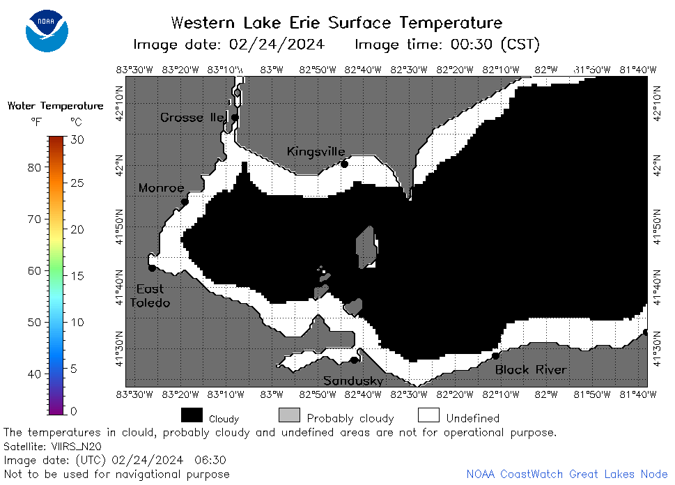
| Dataset Title: | Lake Erie Western Region Surface Temperature Contour Map (2022-present)


|
| Institution: | CoastWatch Great Lakes Node (Dataset ID: LE_NRT_TC_e1) |
| Information: | Summary
| License
| Metadata
| Background | Subset
| Data Access Form
| Make a graph
| Subset
| Data Access Form
| Make a graph
|
![[ICO]](https://apps.glerl.noaa.gov/erddap/images/fileIcons/blank.gif) | Name | Last modified | Size | Description |
|---|---|---|---|---|
![[DIR]](https://apps.glerl.noaa.gov/erddap/images/fileIcons/back.gif) | Parent Directory | - | - | |
![[IMG]](https://apps.glerl.noaa.gov/erddap/images/fileIcons/image2.gif)  | e1_2024_02_24_0110.png | 24-Feb-2024 09:24 | 21290 | |
 | e1_2024_02_24_0150.png | 24-Feb-2024 09:25 | 21218 | |
 | e1_2024_02_24_0200.png | 24-Feb-2024 09:26 | 30524 | |
 | e1_2024_02_24_0250.png | 24-Feb-2024 09:27 | 24270 | |
 | e1_2024_02_24_0340.png | 24-Feb-2024 09:28 | 22264 | |
 | e1_2024_02_24_0630.png | 24-Feb-2024 09:29 | 22042 | |
 | e1_2024_02_24_0720.png | 24-Feb-2024 11:24 | 22033 | |
 | e1_2024_02_24_0810.png | 24-Feb-2024 11:25 | 22146 | |
 | e1_2024_02_24_0900.png | 24-Feb-2024 18:24 | 22257 | |
 | e1_2024_02_24_1410.png | 24-Feb-2024 18:25 | 26419 | |
 | e1_2024_02_24_1500.png | 24-Feb-2024 19:24 | 35998 | |
 | e1_2024_02_24_1550.png | 24-Feb-2024 19:25 | 36875 | |
 | e1_2024_02_24_1640.png | 24-Feb-2024 20:24 | 22292 | |
 | e1_2024_02_24_1700.png | 24-Feb-2024 19:26 | 36193 | |
 | e1_2024_02_24_1730.png | 24-Feb-2024 20:25 | 19504 | |
 | e1_2024_02_24_1750.png | 24-Feb-2024 20:26 | 34987 | |
 | e1_2024_02_24_1840.png | 24-Feb-2024 21:24 | 35742 | |
 | e1_2024_02_24_1930.png | 25-Feb-2024 01:24 | 30213 | |
 | e1_2024_055.png | 25-Feb-2024 10:15 | 30976 | |