
Easier access to scientific data

Brought to you by NOAA CoastWatch Great Lakes Node
|
ERDDAP
Easier access to scientific data |
|
Brought to you by NOAA CoastWatch Great Lakes Node |
| Dataset Title: | Lake Erie Western Region Surface Temperature Contour Map (2022-present)


|
| Institution: | CoastWatch Great Lakes Node (Dataset ID: LE_NRT_TC_e1) |
| Information: | Summary
| License
| Metadata
| Background | Subset
| Data Access Form
| Make a graph
| Subset
| Data Access Form
| Make a graph
|
![[ICO]](https://apps.glerl.noaa.gov/erddap/images/fileIcons/blank.gif) | Name | Last modified | Size | Description |
|---|---|---|---|---|
![[DIR]](https://apps.glerl.noaa.gov/erddap/images/fileIcons/back.gif) | Parent Directory | - | - | |
![[IMG]](https://apps.glerl.noaa.gov/erddap/images/fileIcons/image2.gif)  | e1_2024_02_11_0120.png | 11-Feb-2024 06:26 | 27395 | |
 | e1_2024_02_11_0130.png | 11-Feb-2024 06:28 | 22275 | |
 | e1_2024_02_11_0220.png | 11-Feb-2024 06:30 | 34270 | |
 | e1_2024_02_11_0300.png | 11-Feb-2024 06:33 | 22575 | |
 | e1_2024_02_11_0310.png | 11-Feb-2024 06:35 | 19480 | |
 | e1_2024_02_11_0620.png | 11-Feb-2024 10:26 | 22754 | |
 | e1_2024_02_11_0800.png | 11-Feb-2024 22:26 | 22920 | |
 | e1_2024_02_11_0940.png | 11-Feb-2024 22:28 | 19477 | |
 | e1_2024_02_11_1430.png | 11-Feb-2024 22:30 | 22962 | |
 | e1_2024_02_11_1520.png | 11-Feb-2024 22:32 | 22985 | |
 | e1_2024_02_11_1610.png | 11-Feb-2024 22:35 | 23002 | |
 | e1_2024_02_11_1700.png | 11-Feb-2024 22:37 | 19478 | |
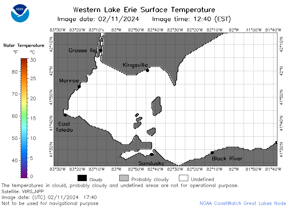 | e1_2024_02_11_1740.png | 11-Feb-2024 21:26 | 21165 | |
 | e1_2024_02_11_1750.png | 11-Feb-2024 22:39 | 22925 | |
 | e1_2024_02_11_1930.png | 11-Feb-2024 23:26 | 23397 | |
 | e1_2024_042.png | 12-Feb-2024 10:15 | 34494 | |