
Easier access to scientific data

Brought to you by NOAA CoastWatch Great Lakes Node
|
ERDDAP
Easier access to scientific data |
|
Brought to you by NOAA CoastWatch Great Lakes Node |
| Dataset Title: | Lake Erie Western Region Surface Temperature Contour Map (2022-present)


|
| Institution: | CoastWatch Great Lakes Node (Dataset ID: LE_NRT_TC_e1) |
| Information: | Summary
| License
| Metadata
| Background | Subset
| Data Access Form
| Make a graph
| Subset
| Data Access Form
| Make a graph
|
![[ICO]](https://apps.glerl.noaa.gov/erddap/images/fileIcons/blank.gif) | Name | Last modified | Size | Description |
|---|---|---|---|---|
![[DIR]](https://apps.glerl.noaa.gov/erddap/images/fileIcons/back.gif) | Parent Directory | - | - | |
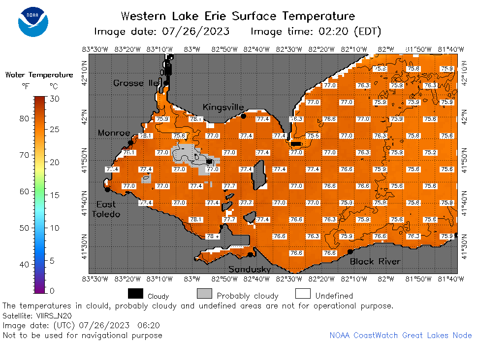
![[IMG]](https://apps.glerl.noaa.gov/erddap/images/fileIcons/image2.gif)  | e1_2023_07_26_0110.png | 26-Jul-2023 05:25 | 34189 | |
 | e1_2023_07_26_0120.png | 26-Jul-2023 05:27 | 28254 | |
 | e1_2023_07_26_0200.png | 26-Jul-2023 05:30 | 46974 | |
 | e1_2023_07_26_0250.png | 26-Jul-2023 05:34 | 40251 | |
 | e1_2023_07_26_0620.png | 26-Jul-2023 09:25 | 40608 | |
 | e1_2023_07_26_0800.png | 26-Jul-2023 11:26 | 40029 | |
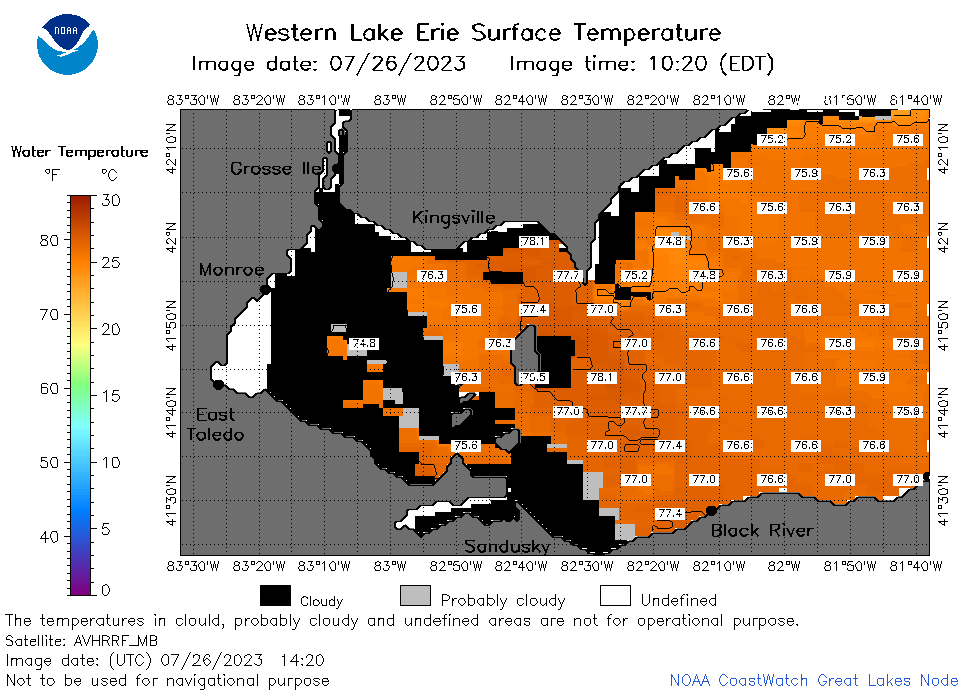 | e1_2023_07_26_1420.png | 26-Jul-2023 18:25 | 30785 | |
 | e1_2023_07_26_1510.png | 26-Jul-2023 19:26 | 35127 | |
 | e1_2023_07_26_1600.png | 26-Jul-2023 19:28 | 21793 | |
 | e1_2023_07_26_1750.png | 26-Jul-2023 21:26 | 20967 | |
 | e1_2023_207.png | 27-Jul-2023 09:15 | 27740 | |