
Easier access to scientific data

Brought to you by NOAA CoastWatch Great Lakes Node
|
ERDDAP
Easier access to scientific data |
|
Brought to you by NOAA CoastWatch Great Lakes Node |
| Dataset Title: | Lake Erie Western Region Surface Temperature Contour Map (2022-present)


|
| Institution: | CoastWatch Great Lakes Node (Dataset ID: LE_NRT_TC_e1) |
| Information: | Summary
| License
| Metadata
| Background | Subset
| Data Access Form
| Make a graph
| Subset
| Data Access Form
| Make a graph
|
![[ICO]](https://apps.glerl.noaa.gov/erddap/images/fileIcons/blank.gif) | Name | Last modified | Size | Description |
|---|---|---|---|---|
![[DIR]](https://apps.glerl.noaa.gov/erddap/images/fileIcons/back.gif) | Parent Directory | - | - | |
![[IMG]](https://apps.glerl.noaa.gov/erddap/images/fileIcons/image2.gif)  | e1_2023_07_06_0130.png | 06-Jul-2023 05:26 | 36090 | |
 | e1_2023_07_06_0220.png | 06-Jul-2023 05:28 | 48076 | |
 | e1_2023_07_06_0310.png | 06-Jul-2023 06:26 | 38440 | |
 | e1_2023_07_06_0650.png | 06-Jul-2023 10:26 | 31179 | |
 | e1_2023_07_06_0740.png | 06-Jul-2023 10:28 | 34016 | |
 | e1_2023_07_06_0830.png | 06-Jul-2023 12:26 | 27697 | |
 | e1_2023_07_06_1430.png | 06-Jul-2023 17:26 | 23100 | |
 | e1_2023_07_06_1530.png | 06-Jul-2023 19:28 | 24071 | |
 | e1_2023_07_06_1610.png | 06-Jul-2023 19:31 | 27040 | |
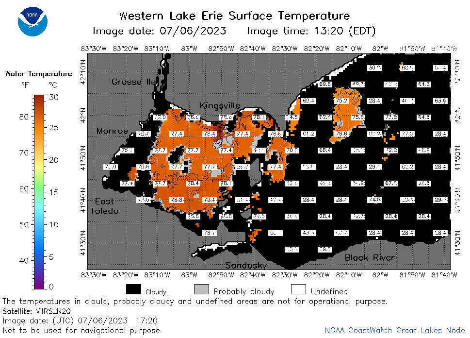 | e1_2023_07_06_1720.png | 06-Jul-2023 19:33 | 34561 | |
 | e1_2023_07_06_1810.png | 06-Jul-2023 22:26 | 44876 | |
 | e1_2023_07_06_1900.png | 06-Jul-2023 22:29 | 36954 | |
 | e1_2023_187.png | 07-Jul-2023 09:15 | 27602 | |