
Easier access to scientific data

Brought to you by NOAA CoastWatch Great Lakes Node
|
ERDDAP
Easier access to scientific data |
|
Brought to you by NOAA CoastWatch Great Lakes Node |
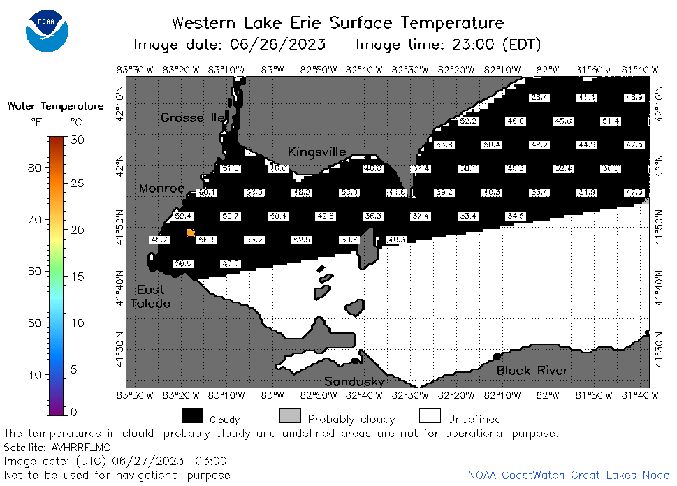
| Dataset Title: | Lake Erie Western Region Surface Temperature Contour Map (2022-present)


|
| Institution: | CoastWatch Great Lakes Node (Dataset ID: LE_NRT_TC_e1) |
| Information: | Summary
| License
| Metadata
| Background | Subset
| Data Access Form
| Make a graph
| Subset
| Data Access Form
| Make a graph
|
![[ICO]](https://apps.glerl.noaa.gov/erddap/images/fileIcons/blank.gif) | Name | Last modified | Size | Description |
|---|---|---|---|---|
![[DIR]](https://apps.glerl.noaa.gov/erddap/images/fileIcons/back.gif) | Parent Directory | - | - | |
![[IMG]](https://apps.glerl.noaa.gov/erddap/images/fileIcons/image2.gif)  | e1_2023_06_27_0120.png | 27-Jun-2023 05:27 | 26206 | |
 | e1_2023_06_27_0200.png | 27-Jun-2023 05:30 | 29159 | |
 | e1_2023_06_27_0250.png | 27-Jun-2023 06:25 | 23913 | |
 | e1_2023_06_27_0300.png | 27-Jun-2023 06:28 | 23574 | |
 | e1_2023_06_27_0620.png | 27-Jun-2023 10:27 | 24797 | |
 | e1_2023_06_27_0710.png | 27-Jun-2023 10:31 | 27787 | |
 | e1_2023_06_27_0800.png | 27-Jun-2023 12:26 | 25891 | |
 | e1_2023_06_27_1420.png | 27-Jun-2023 17:26 | 24199 | |
 | e1_2023_06_27_1510.png | 27-Jun-2023 19:26 | 24272 | |
 | e1_2023_06_27_1600.png | 27-Jun-2023 19:28 | 24291 | |
 | e1_2023_06_27_1740.png | 27-Jun-2023 20:26 | 23775 | |
 | e1_2023_06_27_1830.png | 27-Jun-2023 22:30 | 24912 | |
 | e1_2023_06_27_1920.png | 27-Jun-2023 23:26 | 24039 | |
 | e1_2023_178.png | 28-Jun-2023 09:15 | 30862 | |