
Easier access to scientific data

Brought to you by NOAA CoastWatch Great Lakes Node
|
ERDDAP
Easier access to scientific data |
|
Brought to you by NOAA CoastWatch Great Lakes Node |
| Dataset Title: | Lake Erie Western Region Surface Temperature Contour Map (2022-present)


|
| Institution: | CoastWatch Great Lakes Node (Dataset ID: LE_NRT_TC_e1) |
| Information: | Summary
| License
| Metadata
| Background | Subset
| Data Access Form
| Make a graph
| Subset
| Data Access Form
| Make a graph
|
![[ICO]](https://apps.glerl.noaa.gov/erddap/images/fileIcons/blank.gif) | Name | Last modified | Size | Description |
|---|---|---|---|---|
![[DIR]](https://apps.glerl.noaa.gov/erddap/images/fileIcons/back.gif) | Parent Directory | - | - | |
![[IMG]](https://apps.glerl.noaa.gov/erddap/images/fileIcons/image2.gif)  | e1_2023_06_19_0130.png | 19-Jun-2023 05:26 | 44371 | |
 | e1_2023_06_19_0220.png | 19-Jun-2023 05:28 | 50186 | |
 | e1_2023_06_19_0310.png | 19-Jun-2023 06:26 | 40090 | |
 | e1_2023_06_19_0620.png | 21-Jun-2023 15:15 | 39290 | |
 | e1_2023_06_19_0710.png | 21-Jun-2023 15:19 | 38646 | |
 | e1_2023_06_19_0800.png | 21-Jun-2023 15:23 | 34107 | |
 | e1_2023_06_19_1440.png | 21-Jun-2023 15:33 | 24937 | |
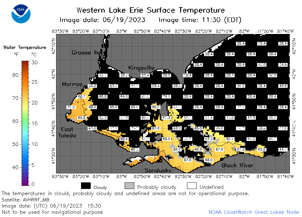 | e1_2023_06_19_1530.png | 21-Jun-2023 15:38 | 31788 | |
 | e1_2023_06_19_1620.png | 21-Jun-2023 15:42 | 33434 | |
 | e1_2023_06_19_1740.png | 21-Jun-2023 15:48 | 39236 | |
 | e1_2023_06_19_1830.png | 21-Jun-2023 15:51 | 32214 | |
 | e1_2023_06_19_1920.png | 21-Jun-2023 15:53 | 26258 | |
 | e1_2023_170.png | 20-Jun-2023 09:16 | 29804 | |