
Easier access to scientific data

Brought to you by NOAA CoastWatch Great Lakes Node
|
ERDDAP
Easier access to scientific data |
|
Brought to you by NOAA CoastWatch Great Lakes Node |
| Dataset Title: | Lake Erie Western Region Surface Temperature Contour Map (2022-present)


|
| Institution: | CoastWatch Great Lakes Node (Dataset ID: LE_NRT_TC_e1) |
| Information: | Summary
| License
| Metadata
| Background | Subset
| Data Access Form
| Make a graph
| Subset
| Data Access Form
| Make a graph
|
![[ICO]](https://apps.glerl.noaa.gov/erddap/images/fileIcons/blank.gif) | Name | Last modified | Size | Description |
|---|---|---|---|---|
![[DIR]](https://apps.glerl.noaa.gov/erddap/images/fileIcons/back.gif) | Parent Directory | - | - | |
![[IMG]](https://apps.glerl.noaa.gov/erddap/images/fileIcons/image2.gif)  | e1_2023_05_25_0150.png | 25-May-2023 05:30 | 47528 | |
 | e1_2023_05_25_0240.png | 25-May-2023 05:32 | 50263 | |
 | e1_2023_05_25_0330.png | 25-May-2023 06:26 | 40565 | |
 | e1_2023_05_25_0640.png | 25-May-2023 10:28 | 38000 | |
 | e1_2023_05_25_0720.png | 25-May-2023 10:30 | 37254 | |
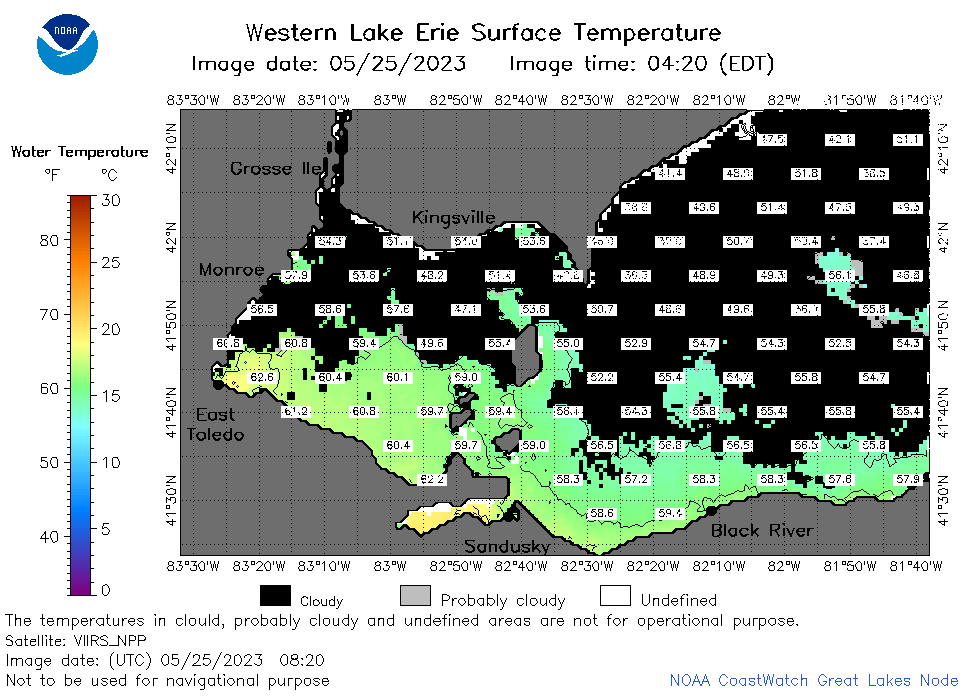 | e1_2023_05_25_0820.png | 25-May-2023 12:28 | 36457 | |
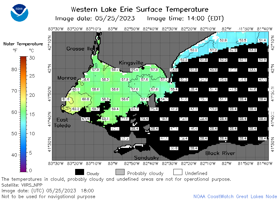
 | e1_2023_05_25_1450.png | 25-May-2023 19:26 | 23747 | |
 | e1_2023_05_25_1500.png | 25-May-2023 19:28 | 21544 | |
 | e1_2023_05_25_1540.png | 25-May-2023 19:30 | 23285 | |
 | e1_2023_05_25_1630.png | 25-May-2023 20:26 | 24789 | |
 | e1_2023_05_25_1710.png | 25-May-2023 19:33 | 26380 | |
 | e1_2023_05_25_1800.png | 25-May-2023 20:32 | 31127 | |
 | e1_2023_05_25_1850.png | 25-May-2023 21:26 | 36296 | |