
Easier access to scientific data

Brought to you by NOAA CoastWatch Great Lakes Node
|
ERDDAP
Easier access to scientific data |
|
Brought to you by NOAA CoastWatch Great Lakes Node |
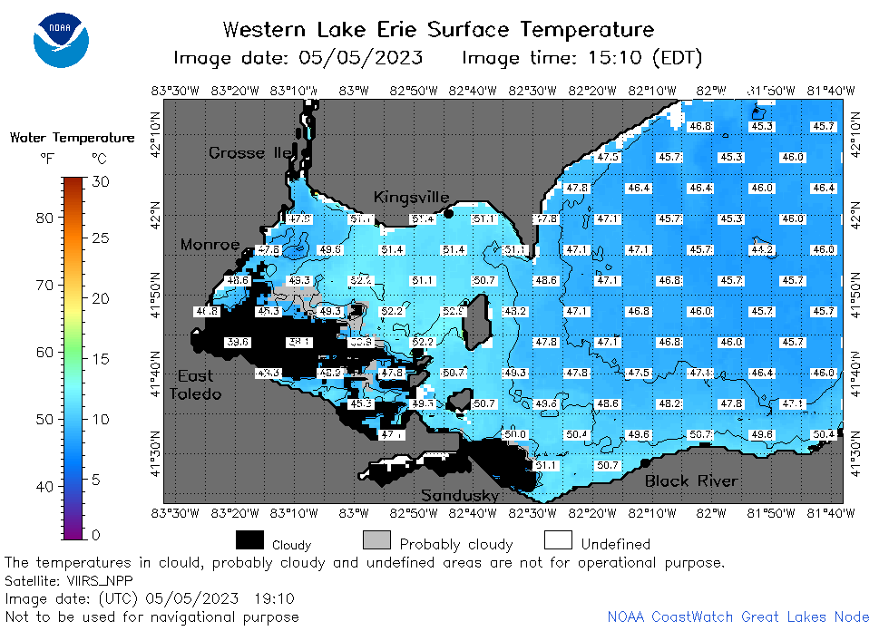
| Dataset Title: | Lake Erie Western Region Surface Temperature Contour Map (2022-present)


|
| Institution: | CoastWatch Great Lakes Node (Dataset ID: LE_NRT_TC_e1) |
| Information: | Summary
| License
| Metadata
| Background | Subset
| Data Access Form
| Make a graph
| Subset
| Data Access Form
| Make a graph
|
![[ICO]](https://apps.glerl.noaa.gov/erddap/images/fileIcons/blank.gif) | Name | Last modified | Size | Description |
|---|---|---|---|---|
![[DIR]](https://apps.glerl.noaa.gov/erddap/images/fileIcons/back.gif) | Parent Directory | - | - | |
![[IMG]](https://apps.glerl.noaa.gov/erddap/images/fileIcons/image2.gif)  | e1_2023_05_05_0110.png | 05-May-2023 05:25 | 35863 | |
 | e1_2023_05_05_0200.png | 05-May-2023 05:29 | 53240 | |
 | e1_2023_05_05_0250.png | 05-May-2023 06:26 | 45843 | |
 | e1_2023_05_05_0610.png | 05-May-2023 10:25 | 40370 | |
 | e1_2023_05_05_0700.png | 05-May-2023 10:28 | 48800 | |
 | e1_2023_05_05_0750.png | 05-May-2023 11:26 | 47949 | |
 | e1_2023_05_05_0840.png | 05-May-2023 11:28 | 30079 | |
 | e1_2023_05_05_1420.png | 05-May-2023 17:27 | 28046 | |
 | e1_2023_05_05_1510.png | 05-May-2023 19:26 | 44377 | |
 | e1_2023_05_05_1600.png | 05-May-2023 19:30 | 44354 | |
 | e1_2023_05_05_1730.png | 05-May-2023 20:28 | 43682 | |
 | e1_2023_05_05_1820.png | 05-May-2023 21:26 | 43222 | |
 | e1_2023_05_05_1910.png | 05-May-2023 22:27 | 43386 | |
 | e1_2023_125.png | 06-May-2023 09:15 | 31116 | |