
Easier access to scientific data

Brought to you by NOAA CoastWatch Great Lakes Node
|
ERDDAP
Easier access to scientific data |
|
Brought to you by NOAA CoastWatch Great Lakes Node |
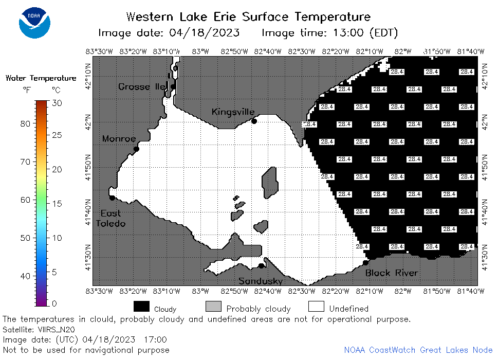
| Dataset Title: | Lake Erie Western Region Surface Temperature Contour Map (2022-present)


|
| Institution: | CoastWatch Great Lakes Node (Dataset ID: LE_NRT_TC_e1) |
| Information: | Summary
| License
| Metadata
| Background | Subset
| Data Access Form
| Make a graph
| Subset
| Data Access Form
| Make a graph
|
![[ICO]](https://apps.glerl.noaa.gov/erddap/images/fileIcons/blank.gif) | Name | Last modified | Size | Description |
|---|---|---|---|---|
![[DIR]](https://apps.glerl.noaa.gov/erddap/images/fileIcons/back.gif) | Parent Directory | - | - | |
![[IMG]](https://apps.glerl.noaa.gov/erddap/images/fileIcons/image2.gif)  | e1_2023_04_18_0110.png | 18-Apr-2023 05:26 | 23153 | |
 | e1_2023_04_18_0200.png | 18-Apr-2023 05:28 | 22918 | |
 | e1_2023_04_18_0250.png | 18-Apr-2023 06:28 | 22119 | |
 | e1_2023_04_18_0630.png | 18-Apr-2023 10:26 | 22141 | |
 | e1_2023_04_18_0720.png | 18-Apr-2023 10:28 | 22366 | |
 | e1_2023_04_18_0810.png | 18-Apr-2023 12:26 | 23303 | |
 | e1_2023_04_18_1420.png | 18-Apr-2023 18:25 | 22009 | |
 | e1_2023_04_18_1510.png | 18-Apr-2023 18:28 | 22167 | |
 | e1_2023_04_18_1600.png | 18-Apr-2023 19:26 | 22296 | |
 | e1_2023_04_18_1700.png | 18-Apr-2023 20:26 | 23048 | |
 | e1_2023_04_18_1750.png | 18-Apr-2023 21:27 | 23484 | |
 | e1_2023_04_18_1840.png | 18-Apr-2023 21:30 | 23693 | |
 | e1_2023_04_18_1930.png | 18-Apr-2023 23:27 | 22725 | |
 | e1_2023_108.png | 19-Apr-2023 09:15 | 33438 | |