
Easier access to scientific data

Brought to you by NOAA CoastWatch Great Lakes Node
|
ERDDAP
Easier access to scientific data |
|
Brought to you by NOAA CoastWatch Great Lakes Node |
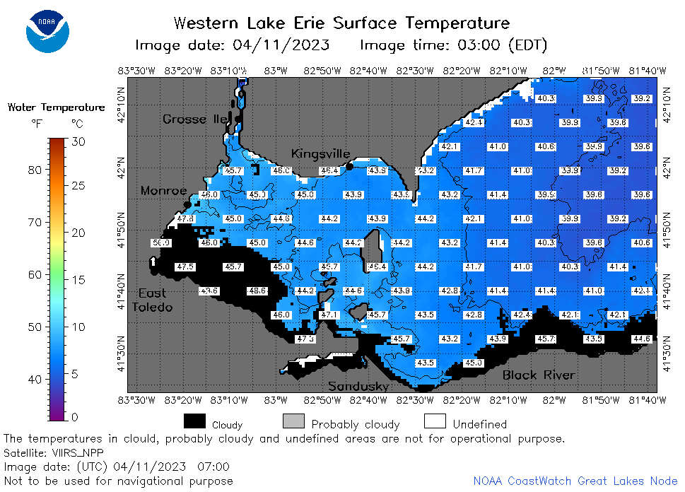
| Dataset Title: | Lake Erie Western Region Surface Temperature Contour Map (2022-present)


|
| Institution: | CoastWatch Great Lakes Node (Dataset ID: LE_NRT_TC_e1) |
| Information: | Summary
| License
| Metadata
| Background | Subset
| Data Access Form
| Make a graph
| Subset
| Data Access Form
| Make a graph
|
![[ICO]](https://apps.glerl.noaa.gov/erddap/images/fileIcons/blank.gif) | Name | Last modified | Size | Description |
|---|---|---|---|---|
![[DIR]](https://apps.glerl.noaa.gov/erddap/images/fileIcons/back.gif) | Parent Directory | - | - | |
![[IMG]](https://apps.glerl.noaa.gov/erddap/images/fileIcons/image2.gif)  | e1_2023_04_11_0110.png | 11-Apr-2023 05:25 | 21718 | |
 | e1_2023_04_11_0200.png | 11-Apr-2023 05:28 | 24408 | |
 | e1_2023_04_11_0250.png | 11-Apr-2023 05:30 | 24205 | |
 | e1_2023_04_11_0610.png | 11-Apr-2023 09:25 | 31136 | |
 | e1_2023_04_11_0700.png | 11-Apr-2023 10:26 | 41890 | |
 | e1_2023_04_11_0750.png | 11-Apr-2023 11:26 | 43639 | |
 | e1_2023_04_11_1510.png | 11-Apr-2023 19:28 | 30178 | |
 | e1_2023_04_11_1550.png | 11-Apr-2023 18:26 | 32928 | |
 | e1_2023_04_11_1730.png | 11-Apr-2023 20:28 | 35162 | |
 | e1_2023_04_11_1820.png | 11-Apr-2023 21:29 | 32839 | |
 | e1_2023_04_11_1910.png | 11-Apr-2023 22:26 | 25709 | |