
Easier access to scientific data

Brought to you by NOAA CoastWatch Great Lakes Node
|
ERDDAP
Easier access to scientific data |
|
Brought to you by NOAA CoastWatch Great Lakes Node |
| Dataset Title: | Lake Erie Western Region Surface Temperature Contour Map (2022-present)


|
| Institution: | CoastWatch Great Lakes Node (Dataset ID: LE_NRT_TC_e1) |
| Information: | Summary
| License
| Metadata
| Background | Subset
| Data Access Form
| Make a graph
| Subset
| Data Access Form
| Make a graph
|
![[ICO]](https://apps.glerl.noaa.gov/erddap/images/fileIcons/blank.gif) | Name | Last modified | Size | Description |
|---|---|---|---|---|
![[DIR]](https://apps.glerl.noaa.gov/erddap/images/fileIcons/back.gif) | Parent Directory | - | - | |
![[IMG]](https://apps.glerl.noaa.gov/erddap/images/fileIcons/image2.gif) 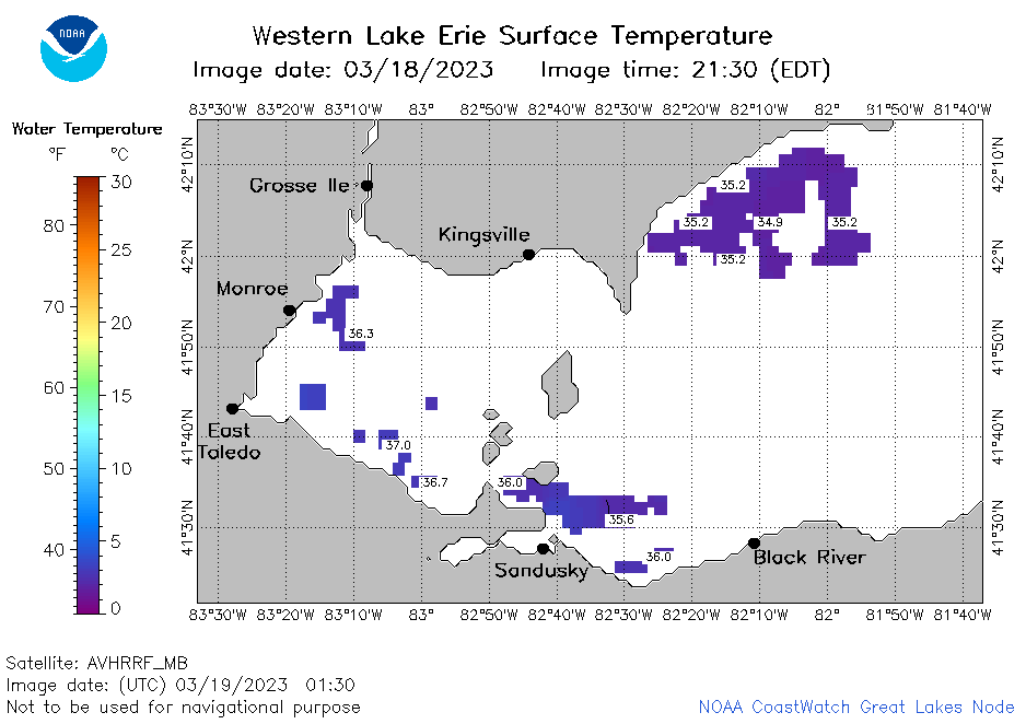 | e1_2023_03_19_0130.png | 19-Mar-2023 05:24 | 20706 | |
 | e1_2023_03_19_0220.png | 19-Mar-2023 05:25 | 22464 | |
 | e1_2023_03_19_0310.png | 19-Mar-2023 06:24 | 20165 | |
 | e1_2023_03_19_0640.png | 19-Mar-2023 10:24 | 20114 | |
 | e1_2023_03_19_0730.png | 19-Mar-2023 11:24 | 20363 | |
 | e1_2023_03_19_0820.png | 19-Mar-2023 11:25 | 19543 | |
 | e1_2023_03_19_1440.png | 19-Mar-2023 18:24 | 20326 | |
 | e1_2023_03_19_1530.png | 19-Mar-2023 18:25 | 19788 | |
 | e1_2023_03_19_1620.png | 19-Mar-2023 20:24 | 19556 | |
 | e1_2023_03_19_1720.png | 19-Mar-2023 21:24 | 21213 | |
 | e1_2023_03_19_1800.png | 19-Mar-2023 20:26 | 23370 | |
 | e1_2023_03_19_1900.png | 19-Mar-2023 21:25 | 25186 | |
 | e1_2023_078.png | 20-Mar-2023 09:15 | 29766 | |