
Easier access to scientific data

Brought to you by NOAA CoastWatch Great Lakes Node
|
ERDDAP
Easier access to scientific data |
|
Brought to you by NOAA CoastWatch Great Lakes Node |
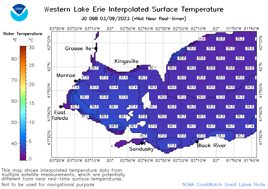
| Dataset Title: | Lake Erie Western Region Surface Temperature Contour Map (2022-present)


|
| Institution: | CoastWatch Great Lakes Node (Dataset ID: LE_NRT_TC_e1) |
| Information: | Summary
| License
| Metadata
| Background | Subset
| Data Access Form
| Make a graph
| Subset
| Data Access Form
| Make a graph
|
![[ICO]](https://apps.glerl.noaa.gov/erddap/images/fileIcons/blank.gif) | Name | Last modified | Size | Description |
|---|---|---|---|---|
![[DIR]](https://apps.glerl.noaa.gov/erddap/images/fileIcons/back.gif) | Parent Directory | - | - | |
![[IMG]](https://apps.glerl.noaa.gov/erddap/images/fileIcons/image2.gif)  | e1_2023_03_09_0140.png | 09-Mar-2023 06:24 | 27192 | |
 | e1_2023_03_09_0230.png | 09-Mar-2023 06:25 | 27045 | |
 | e1_2023_03_09_0320.png | 09-Mar-2023 06:26 | 27091 | |
 | e1_2023_03_09_0630.png | 09-Mar-2023 10:24 | 27911 | |
 | e1_2023_03_09_0720.png | 09-Mar-2023 11:24 | 25624 | |
 | e1_2023_03_09_0810.png | 09-Mar-2023 12:24 | 25769 | |
 | e1_2023_03_09_1630.png | 09-Mar-2023 20:24 | 20683 | |
 | e1_2023_03_09_1700.png | 09-Mar-2023 20:25 | 20838 | |
 | e1_2023_03_09_1750.png | 09-Mar-2023 21:25 | 28148 | |
 | e1_2023_03_09_1840.png | 09-Mar-2023 21:26 | 26086 | |
 | e1_2023_03_09_1930.png | 09-Mar-2023 22:24 | 21668 | |
 | e1_2023_068.png | 10-Mar-2023 10:15 | 29924 | |